|
Peñasquitos and Highway 56 LoopSan Diego, California |
Please e-mail comments, corrections and additions to the webmaster at pje@efgh.com.
|
|
Peñasquitos and Highway 56 LoopSan Diego, California |
Please e-mail comments, corrections and additions to the webmaster at pje@efgh.com.
CONSTRUCTION ALERT: The northern part of Sorrento Valley Blvd. is temporarily closed to bicyclists. To detour around the closed area, turn right on Carmel Mountain Road and left on El Camino Real. The closed area is supposed to reopen about May 2005.
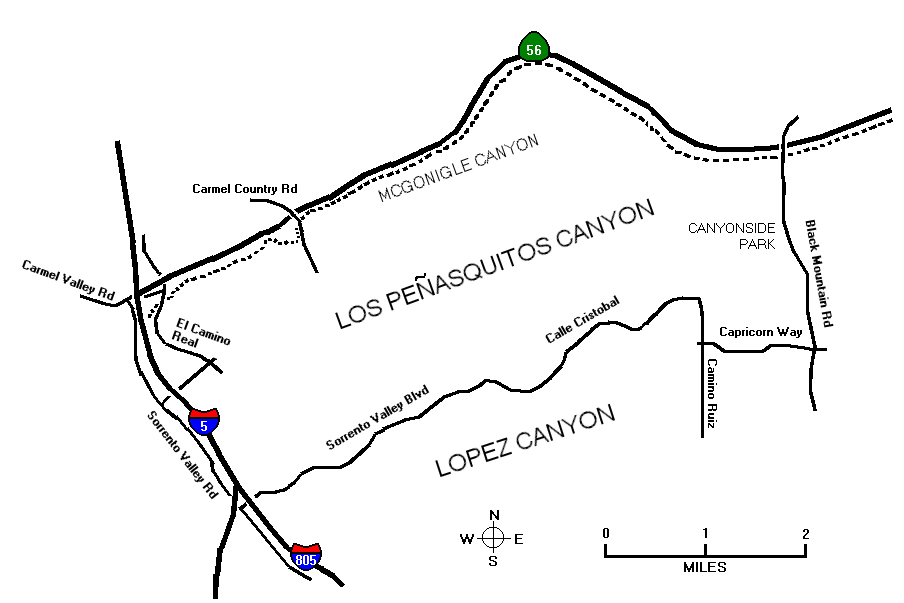
This is a moderately hilly 20-mile road ride around Peñasquitos Canyon and along Highway 56 through McGonigle Canyon. It should take slightly less than two hours.
The ride begins and ends at Canyonside Park on the west side of Black Mountain Road just north or Mercy Road. Parking is free. Water and rest rooms are available.
Approximate distances from the starting point are given in miles.
0.00 START at Canyonside Park and go south on Black Mountain Rd.
1.19 RIGHT on Capricorn Way. (This turn is prohibited 6 AM to 9 AM, Monday to Friday, but bicyclists can make the turn legally by walking their bikes on the sidewalk.)
2.36 RIGHT on Camino Ruiz.
2.86 LEFT on Calle Cristobal. Just north of this intersection is construction for Camino Ruiz Neighborhood Park.
Calle Cristobal runs west along López Ridge between López Canyon to the south and Peñasquitos Canyon to the north. Although the area is developed, good views of both canyons are available from some places. Click here for a typical view.
4.68 PASS López Ridge Park, a possible alternative starting and ending point.
7.32 PASS Peñasquitos Park entrance, a possible alternative starting and ending point.
8.42 RIGHT on Sorrento Valley Rd.
8.67 PASS Sorrento Valley Coaster Station, a possible alternative starting and ending point for bicyclists who ride the Coaster.
9.88 ENTER part of Sorrento Valley Road which is closed to automobiles (except wastewater maintenance vehicles), but open to pedestrians and bicycles. The lagoon and marsh to the west are part of Torrey Pines State Reserve. Click here for a photograph.
10.98 RIGHT on Carmel Valley Rd.
11.39 RIGHT on El Camino Real.
11.50 RIGHT into path, marked only by a sign saying "pedestrians and motor-driven cycles prohibited". Turn right again and pass under El Camino Real.
13.29 PASS parking area on Carmel Country Road, a possible alternative starting and ending point. Continue on the path, which runs under Carmel Country Road and then across Carmel Valley Creek on a small causeway.
NOTE: If the causeway is flooded, go up to Carmel Country Road and use a pedestrian crossing signal. Reenter the path on the other side.
14.24 LEFT at the end of the built-up area. Pass between some bollards, cross a paved area and enter another bike path which runs next to Highway 56. (See photograph.)
14.85 CROSS Carmel Valley Rd. at a pedestrian crossing.
17.98 CROSS Camino Del Sur. at a pedestrian crossing.
19.43 RIGHT on Black Mountain Rd.
20.31 FINISH at Canyonside Park.
Last surveyed December 9, 2004.