Name:        LOW
Identifier:  DX3926
Lat/Lon:     N 33° 0.130 W 117° 10.144
Elevation:   392 FEET
Year:
Address:     17520 SAN DIEGUITO RD, SAN DIEGO CA 92127
Vicinity:    click here
Survey Date: 2/5/2015
Description: click here
Page 7 of 7 previous page |
|
| Name: LOW Identifier: DX3926 Lat/Lon: N 33° 0.130 W 117° 10.144 Elevation: 392 FEET Year: Address: 17520 SAN DIEGUITO RD, SAN DIEGO CA 92127 Vicinity: click here Survey Date: 2/5/2015 Description: click here |
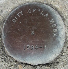
| Name: 1994-1 Identifier: Lat/Lon: N 32° 46.092 W 117° 0.532 Elevation: 588 FEET Year: 1994 Address: 8742 LEMON AVE, LA MESA CA 91941 Vicinity: click here Survey Date: 2/1/2015 Description: click here |
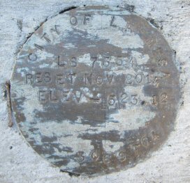
| Name: LS 7354 Identifier: Lat/Lon: N 32° 45.380 W 117° 1.671 Elevation: 546 FEET Year: 2014 Address: 7901 CINNABAR DR, LA MESA CA 91941 Vicinity: click here Survey Date: 2/1/2015 Description: click here |
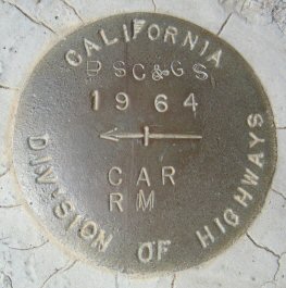
| Name: CAR RM Identifier: DC1459 Lat/Lon: N 32° 46.996 W 117° 3.188 Elevation: 711 FEET Year: 1964 Address: 6630 NORMAN LN, SAN DIEGO CA 92120 Vicinity: click here Survey Date: 2/19/2015 Description: click here |
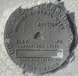
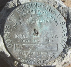
| Name: SP9 Identifier: Lat/Lon: N 32° 57.466 W 116° 18.102 Elevation: 1233 FEET Year: Address: 39555 GREAT SOUTHERN OVERLAND STAGE ROUTE, JULIAN CA 92036 Vicinity: click here Survey Date: 2/21/2015 Description: click here |
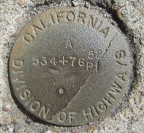
| Name: 534-76 Identifier: Lat/Lon: N 32° 44.671 W 116° 58.453 Elevation: 556 FEET Year: Address: 10198 CAMPO RD, SPRING VALLEY CA 91977 Vicinity: click here Survey Date: 3/6/2015 Description: click here |
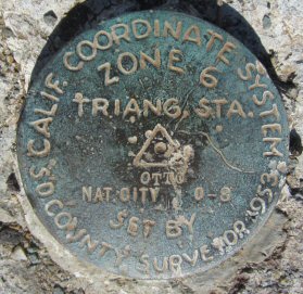
| Name: OTTO Identifier: Lat/Lon: N 32° 41.298 W 117° 0.509 Elevation: 425 FEET Year: Address: 3218 SUMMIT MEADOW RD, BONITA CA 91902 Vicinity: click here Survey Date: 2/10/2015 Description: click here |
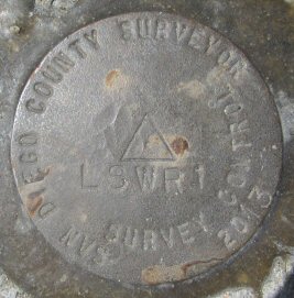
| Name: LSWR1 Identifier: Lat/Lon: N 32° 40.567 W 117° 1.022 Elevation: 114 FEET Year: 2013 Address: 5470 BONITA RD, BONITA CA 91902 Vicinity: click here Survey Date: 4/2/2015 Description: click here |
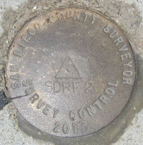
| Name: SDRF2 Identifier: Lat/Lon: N 32° 51.889 W 116° 55.641 Elevation: 402 FEET Year: 2013 Address: 10300 CHANNEL RD, LAKESIDE CA 92040 Vicinity: click here Survey Date: 5/11/2015 Description: click here |
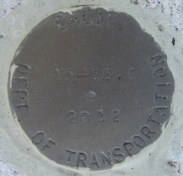
| Name: 15-15.0 Identifier: Lat/Lon: N 32° 54.213 E 117° 6.993 Elevation: 541 FEET Year: 2012 Address: 9750 CARROLL CANYON RD, SAN DIEGO CA 92126 Vicinity: click here Survey Date: 6/5/2015 Description: click here |
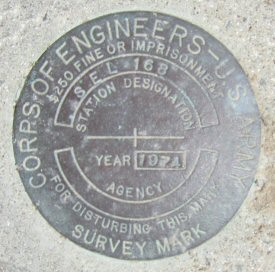
| Name: SEL 168 Identifier: Lat/Lon: N 33° 0.514 W 117° 15.431 Elevation: 6 FEET Year: 1974 Address: 3250 MANCHESTER AVE, CARDIFF-BY-THE-SEA CA 92007 Vicinity: click here Survey Date: 8/29/2015 Description: click here |
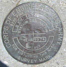
| Name: SEL 167 Identifier: Lat/Lon: N 33° 0.519 W 117° 15.539 Elevation: 6 FEET Year: 1974 Address: 3250 MANCHESTER AVE, CARDIFF-BY-THE-SEA CA 92007 Vicinity: click here Survey Date: 8/29/2015 Description: click here |
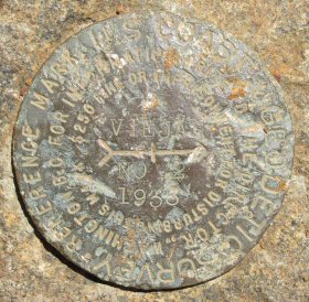
| Name: VIEJAS NO 2 Identifier: DC1993 Lat/Lon: N 32° 51.675 W 116° 43.561 Elevation: 4172 FEET Year: 1933 Address: 89 BOUNDARY TRUCK TRAIL WEST, ALPINE CA 91901 Vicinity: click here Survey Date: 5/26/2016 Description: click here |
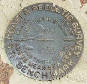
| Name: N308 Identifier: DC1360 Lat/Lon: N 32° 59.197 W 116° 35.015 Elevation: 4642 FEET Year: 1955 Address: 15027 HIGHWAY 79, JULIAN CA 92036 Vicinity: click here Survey Date: 8/9/2016 Description: click here |
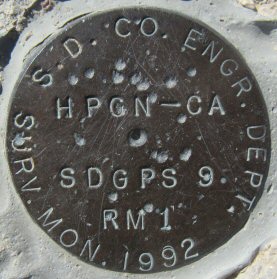
| Name: HPGN-CA Identifier: Lat/Lon: N 33° 15.420 W 116° 13.983 Elevation: 1283 FEET Year: 1992 Address: COUNTY HIGHWAY S22, BORREGO SPRINGS CA 92004 Vicinity: click here Survey Date: 12/17/2016 Description: click here |