|
|
The Sidewalks of North Park
|
Some of the history of North Park, like most older neighborhoods in San Diego, is literally cast in concrete. Early developers and contractors often put their names, the dates and other information into permanent marks on the sidewalks and curbs.
Many of these old marks are still visible, and often they tell a story.
For example, I live at the southwest corner of Polk Ave. and Ohio St., where there are four such marks.
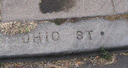
A mark on the curbstone of Ohio St. suggests that this street was built
in August 1913 by a contractor or developer named Gabrielson:

A mark on the same curb gives the street name:
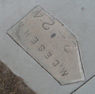
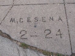
A mark on the sidewalk suggests that it was added later, by a developer or
contractor named M. Cesena:
Just around the corner is a mark for Polk Ave:
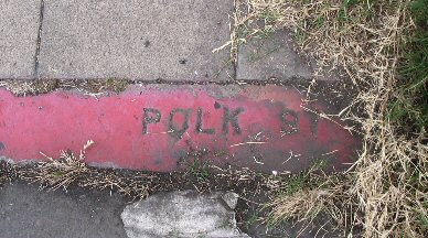
Notice that the mark says "POLK ST", even though the street is currently
signed as "Polk Ave." Inconsistency in the use of "Street" and "Avenue"
is common in curb and sidewalk marks. The names may have been changed,
or the contractors may have paid little attention to the distinction.
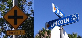
The confusion continues to this very day:
However, there are many places where a street name on a curb or sidewalk mark is obviously different from the name on modern street signs. Presumably, these streets (or parts of them) have been renamed. Here are some of the changes, as evidenced by sidewalk and curb marks:
| current name | former name |
|---|---|
| 29th St. | Kansas St. |
| 30th St. | Nebraska St. |
| 33rd Pl. | Mechanic St. |
| 34th St. | Scott St. |
| 35th St. | Pacific St. |
| Landis St. | Castle St. |
| North Park Way | Wightman St. |
| Pershing Ave. | Oregon St. |
| Polk Ave. | Anna Ave. |
| Wightman St. | Klauber St. |
Most of the old curb and sidewalk marks are still legible.
Some have deteriorated where the pavement has cracked. But many more of
them have been obliterated by later construction, especially by curb cuts.
For example, this
mark at the northwest corner of Upas St. and 32nd St. has been almost
completely obliterated by a new curb cut:
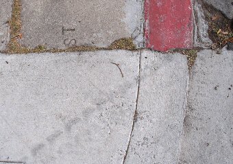
It probably said "32ND ST" or "32 ST" before the curb cut was installed.
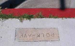
However, it appears that some developers have started to preserve old
marks when pouring new sidewalks. At the southwest corner of Polk Ave.
and Alabama St., the developer removed the old mark and embedded it in
the new concrete:
In an attempt to preserve these little bits of history, I have photographed and indexed all the sidewalk and curb marks that I can find in the North Park area (bounded by Park Blvd., Adams Ave., 35th St. and Upas St.).
Marks on the north side of Adams Ave., the south side of Upas St., the east side of 35th St. and the west side of Park Blvd. are not included, because these are considered to be outside the mapped area.
The index is a database file in dBase format:
marks.dbfYou should be able to download this file to your own computer by clicking on the filespecs and then choosing the "save to disk" option. Some browsers may require a right-click for this option.
After you have saved the file, you can import it into most database management systems, or you may be able to view and process it in dBase format.
The file contains eight fields:
Name Type Description NORTHSOUTH Character north-south street EASTWEST Character east-west street CORNER Character corner of intersection (NE, NW, SE or SW) OFFSET Character offset from corner of intersection TEXT Character text of mark NUMBER 4-digit Integer number of photograph DATE Date date of photograph REMARKS Character additional information, if needed
Most of the marks are at corners of intersections. For these marks, the OFFSET field is blank. In other cases, the mark is not at a corner but is some distance away from it. The OFFSET field in such cases indicates the direction and relative distance. For instance, offsets of N1, N2 and N3 indicate marks at increasing distances north of the corner. The offset is from one of the two adjacent corners, but not always from the nearer one.
Some intersections don't have four corners because one of the streets doesn't go all the way through it. However, for the purposes of this database, the missing corners are presumed to be approximately where they would be if the streets went all the way through.
All but two of the streets in North Park run unambiguously north-south or east-west. Two exceptions are Mission Ave. and Boundary St. Each is listed as a north-south street if the other intersecting street is east-west, and vice-versa. Fortunately, they do not intersect each other!
Some of the marks are located at the intersections of streets and alleys. This presents a special problem because alleys don't have names. Therefore, for the purposes of this database, each east-west alley bears the name of the east-west street just south of it, and each north-south alley bears the name of the north-south street just west of it.
Each mark has been photographed. The photographs were taken at various times of the day and under various lighting conditions, so their quality also varies. To provide some additional information, each photograph was taken so that north side of the mark appears toward the top of the image. If this is objectionable, an image editor can be used to rotate the mark into a readable position.
The photographs have not been posted because there are more than 2,000 of them and each one is a JPEG file approximately 500 to 900 KB in size. Posting them would exceed the capacity of this Web site. However, the images are available on CD-ROMs. E-mail the webmaster at pje@efgh.com for details.
The text of each mark, to the extent it is legible, has been included in the database. Most punctuation (especially periods and hyphens) has been omitted, and dates have been recorded with hyphens, even though the mark itself may or may not have used a hyphen to separate the month from the year. Illegible data is represented by question marks. In some cases, illegible portions were filled in by comparison to nearby marks or other reasonable assumptions.
Some marks contain obvious spelling errors, which were not corrected in the database. One example: "AROZANO ST" at the northwest corner of Arizona St. and Howard Ave.
Apparently, only upper-case letters are used in pavement marks. A few lower-case letters were found embedded in upper-case words and were changed to upper-case in the database to facilitate text searches.
Therefore, the database TEXT field should by used only as an aid in finding marks. It should not be taken as an accurate transcript, even for completely legible marks.
In any compendium of this size, some errors, omissions and duplications are to be expected. It is virtually certain that I have missed some marks because they were obscured by dirt, vegetation or new pavement when I went looking for them. It is likely that I simply overlooked a few marks. But I am confident that nearly all of the surviving history in these marks has been saved from the jackhammer.
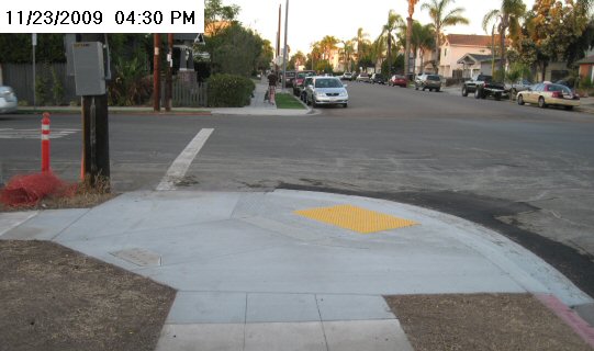
In November 2009, curb cuts and yellow skid plates were installed at
three corners of the intersection of Polk Ave. and Ohio St., including
the southwest corner described above. The "OHIO ST" mark on the curb
was lost, but the other two curb marks were untouched. The sidewalk
mark was saved and set into the new pavement: