|
|
The Streets of Central San DiegoPhilip J. Erdelsky, pje@efgh.com |
Most of central San Diego lies on a plateau about 350-400 feet above sea level. Although the area has no perennial streams, it is cut by numerous canyons of various sizes.
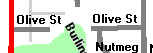
A glance at a street map shows where the canyons are. Nearly all streets run north-south or east-west. Very few of them are built along the natural contours of the land. If the sides of a canyon are very steep, a street may come to an abrupt end on one side of the canyon and begin on the other, as Olive Street does where it crosses Switzer Canyon:
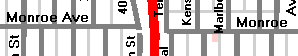
Streets may also be interrupted by freeways, parks or schools:
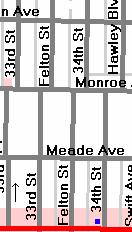
Some streets are quite long and broken into as many as a half-dozen segments. This can make it very difficult to reach an address by following a street!
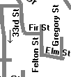
In a few places, the practice of imposing a rectangular street pattern on hilly terrain produces some complicated street configurations:
Fortunately, the house numbering system in this area is quite uniform and consistent in most cases:
House numbers on north-south streets are approximately as follows (in order, from north to south):
| intersecting east-west street | approximate house number on north-south street |
|---|---|
| Copley Ave | 4900 |
| Collier Ave | 4800 |
| Adams Ave | 4700 |
| Madison Ave | 4600 |
| Monroe Ave | 4500 |
| Meade Ave | 4400 |
| El Cajon Blvd | 4300 |
| Howard Ave Orange Ave | 4200 |
| Polk Ave | 4100 |
| Washington St Lincoln Ave | 4000 |
| University Ave | 3900 |
| Robinson Ave Wightman St | 3800 |
| Pennsylvania Ave Landis St | 3700 |
| Brookes Ave Dwight St | 3600 |
| Walnut Ave Myrtle Ave | 3500 |
| Upas St | 3400 |
| Thorn St | 3300 |
| Spruce St | 3200 |
| Redwood St | 3100 |
| Quince St | 3000 |
| Palm St | 2900 |
| Olive St | 2800 |
| Nutmeg St | 2700 |
| Maple St | 2600 |
| Laurel St | 2500 |
| Kalmia St | 2400 |
| Juniper St | 2300 |
| Ivy St | 2200 |
| Hawthorn St | 2100 |
| Grape St | 2000 |
| Fir St | 1900 |
| Elm St | 1800 |
| Date St | 1700 |
| Cedar St | 1600 |
| Beech St | 1500 |
| Ash St | 1400 |
| A St | 1300 |
| B St | 1200 |
| C St | 1100 |
| Broadway | 1000 |
| E St | 900 |
| F St | 800 |
| G St | 700 |
| Market St | 600 |
| Island Ave | 500 |
| J St | 400 |
| K St | 300 |
| L St | 200 |
| Imperial Ave | 100 |
| Commercial St | 1 |
The street names themselves show several patterns. To the south are streets identified by letters, in alphabetical order from north to south, with a few exceptions. Streets that would be called D, H and I Streets are called Broadway, Market St. and Island Ave., respectively. In the middle are the "plant" streets, in alphabetical order from south to north. To the north are streets whose names appear to be surnames, in no particular order.
There are also a number of north-south streets named after states. They do not appear to be in any particular order.
In the western part of central San Diego, there are a number of "bird" streets, in alphabetical order from east to west:
Closer inspection of a street map shows that even continuous streets may be more or less misaligned when they cross other streets. This usually occurs the edges of old development tracts where developers did not coordinate their plans. The pattern of alleys (or the lack thereof) often shows clearcut changes in the same places.