|
|
California Highway 75November 17, 2002 - Philip J. Erdelsky, pje@efgh.com |
California Highway 75 begins at an interchange with Interstate Highway 5 south of Chula Vista. It runs west through Imperial Beach and north along the Silver Strand to Coronado. It then crosses the Coronado Bridge and ends at another interchange with Interstate Highway 5.
California Highway 75 is a scenic route, especially along the Silver Strand and the Coronado Bridge.
The following table lists the major intersections and landmarks on California Highway 75.
| miles from south end | left (for northbound traveler) | control | right (for northbound traveler) | remarks |
|---|---|---|---|---|
| 0.0 | Interstate Highway 5 | interchange | Interstate Highway 5 | |
| 0.3 | Saturn Blvd | traffic light | Saturn Blvd | |
| 1.0 | 13th St | traffic light | 13th St | |
| 1.2 | Florida St | traffic light | Florida St | |
| 1.5 | 9th St | traffic light | 9th St | |
| 1.7 | 7th St, Palm Ave | traffic lights | 7th St | |
| 3.0 | South Bay Marine Biology Study Area | accessible only from northbound lanes | ||
| 4.9 | Silver Strand State Beach | traffic light (northbound) interchange (southbound | Coronado Cays Blvd | |
| 5.2 | traffic light | Coronado Bay Rd | ||
| 6.6 | traffic light | Leyte Rd | ||
| 6.9 | Fiddlers Cove Marina | |||
| 8.5 | Naval Amphibious Base Entrance | accessible only from frontage road | ||
| 9.0 | Avenida de las Arenas | traffic light | Strand Way | |
| 9.4 | traffic light | Pomona Ave | ||
| 9.5 | R H Dana Place | traffic light | Adella Ave | |
| 9.8 | 10th St | traffic light | 10th St | |
| 10.0 | 8th St | traffic light | 8th St | |
| 10.2 | 6th St | traffic light | 6th St | |
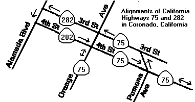
| 10.5 | California Highway 282, 4th St | traffic light | California Highway 75 NORTH, 4th St | see note below |
| 12.8 | Interstate Highway 5 NORTH | interchange | Interstate Highway 5 SOUTH, National Ave |
Note: Northbound California Highway 75 turns right onto 4th St., which is one-way. Southbound California Highway 75 runs along 3rd St., which is parallel to 4th St. and one-way in the opposite direction.