|
|
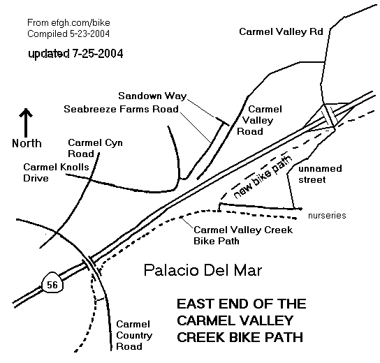
Bicycling Through East Carmel Valley |
When the eastern part of the Carmel Valley Creek Bike Path was opened to the public, the eastern part of the Highway 56 freeway was closed to bicyclists. Recent construction on Highway 56 has disrupted bicycle travel in this area even more. Alternate routes are available, but signage is poor and they may be hard to follow. Some of the roads are so new that they aren't in the 2004 Thomas Guide and some aren't even signed.
There are two alternate routes. The official route is poorly signed. The unofficial route is completely unsigned. Ironically, the unofficial route is probably closer to the final location of the planned bike path. Westbound bicyclists who don't know the way will probably find this route simply by following their noses.
Follow the path under Carmel Country Road and across the creek on a small causeway. On the other side of the creek, turn left and ride up a steep path to the east side of Carmel Country Road.
If the causeway is flooded, you can cross Carmel Country Road at a pedestrian crosswalk just south of the ramps to and from eastbound Highway 56.
Go north on Carmel Country Road, then turn right on Carmel Canyon Road right again on Carmel Knolls Drive, and right again on Seabreeze Farms Road. All of these turns are signed.
At the north end of Seabreeze Road, turn right on Sandown Way, go through some bollards and turn left on Carmel Valley Road. Construction on Highway 56 has turned this part of Carmel Valley Road from a busy arterial into a quiet cul-de-sac.
Continue east on Carmel Valley Road and make a left turn at a traffic light to stay on Carmel Valley Road. The intersection is new and still mostly unsigned.
Continue on the path through a residential area along the north side of a street called Ruette de Mer, a private road that is not open to the public.
The path veers away from Ruette de Mer and eventually leaves the residential area. To the left there used to be a gate; now there is a fence. Follow a small but well-trodden path around the west end of the fence. (If this part is impassible, turn around and use the official route.)
Turn right and ride along an old road parallel to the path. (The road to the left has been obliterated by construction on Highway 56.)
Follow this road to a point near the end of the path. Turn left and follow a newer road up and across the new Highway 56. (There is a rough spot in this road where it crosses an arroyo.) The road runs right into the unsigned intersection described above. Continue straight ahead to go east on Carmel Valley Road.
Turn right to stay on Carmel Valley Road at the first traffic light after Santa Fe Farms Road. (The road straight ahead has bike lanes, but it is not the official bike route.)
Turn right into Sandown Way, passing between bollards. (If you miss this turn, you will soon realize your mistake, because Carmel Valley Road comes to an abrupt end about 0.2 miles farther down the hill.)
Turn left on Seabreeze Farms Drive, left on Carmel Knolls Drive, left on Carmel Canyon Road, and left again on Carmel Country Road.
Cross over Highway 56 and turn right to join the Carmel Creek Bike Path where it runs near the west side of the road.
If you miss the first turn on the official route, you will find yourself on the unofficial route. But it looks official, with bike lanes and bike lane signs.
Follow the road over Highway 56 and down toward the nurseries. Although the road is mostly new, there is a rough spot where it crosses and arroyo.
At the bottom of the hill, turn right onto an older road. (There is a gate here, but the owners of the nurseries will presumably keep it open for their customers.) Follow the older road to the place where it has been obliterated by construction on Highway 56.
To the left is a fence, and the Carmel Valley Creek Bike Path is on the other side. Go around the fence at the far side to enter the path.
If the route around the fence is impassible, turn around and use the official route.
On July 17, 2004, the West Ted Williams Bike Path was extended along the south side of Highway 56 to join the Carmel Valley Creek Bike Path. The highway was opened to motor behicle traffic on July 19, but the new path will be closed from time to time for about a month while the fences and other things are finished. When the new path is open, it will be better route than either detour.
Please e-mail comments, corrections and additions to the webmaster at pje@efgh.com.