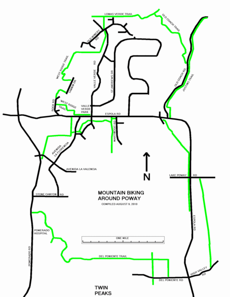
Mountain Biking Around Poway
Poway, California
August 8, 2010
Please e-mail comments, corrections and additions to the webmaster at
pje@efgh.com.
Bicycles are permitted on all the multiple-use trails of Poway, except
those inside the Blue Sky Ecological Reserve.
Trail maps are available, but they are of limited use because they show
only the approximate
locations of most trails. To find out exactly where the trails are, you have
to explore. But at least they tell you where to look.
In some places, a riding and hiking trail is marked by a wooden post with
images of a footprint and a horseshoe burned into its top.
There are many trail signs, but they are not complete. Many of them lack
the trail name. Some trails are marked only by "no motor vehicles" signs
or signs giving the names of volunteers who maintain them.
This is a twelve-mile ride around northern Poway, mostly on
unpaved trails, and including some of the most scenic trails.
Directions
-
00.00 - Start at Valle Verde Park, which is at the northwest corner of
Espola Rd. and Valle Verde Rd. (Thomas 1170 D3). Enter the signed
West Ridge Trail and follow it west along the north side of Espola Rd.
(You may ride on the shoulder of Espola Rd. if you prefer.)
00.23 - Opposite 16840 Espola Rd., turn right and to follow a trail
next to a drainage ditch.
Follow the trail north, then east, and then north
again, and then east again. The last part is apparently shared with a
driveway, which emerges on Rock Road.
- 00.49 - Turn right on Rock Road and follow it north. There is a
trail of sorts along the right side of the road, but most mountain
bikers will prefer to ride on the road. There is a drainage ditch
along the left side.
- 00.58 - At the end of the drainage ditch, turn left into a dirt path.
Follow the path north and then east. To the north, on a hill above you, are
the playing fields for Chaparral School. This part of the trail was marked as a
"nature trail" on an old Poway Trail Guide, and there are remains of nature trail
signs in some places.
- 00.80 - The trail emerges at the south end of Tannin Drive. Turn left and
follow Tannin Drive north past Chaparral School. You may wish to ride on
the sidewalk.
- 00.97 - Just north of the school, turn left into a trail that runs along
the north edge of the school grounds.
- 01.08 - The trail runs just north of the end of a cul-de-sac. Turn right
and follow the trail uphill. The trail winds around the top of a small hill
and goes down the other side. Stop from time to time to enjoy the views. The
trail then levels out widens into a dirt road, and runs through a residential
area.
- 01.84 - The trail turns left. There is a no-trespassing sign on the
road straight ahead. It leads directly to Valle Verde Rd. and can be
used for emergency access to the trail.
- 01.96 - Ignore the Stone Ridge Trail sign.
- 02.17 - Cross Old Winery Rd. and enter the signed
Lomas Verde Trail on the other side.
- 02.37 - At a shaded T intersection of trails turn right to follow
Lomas Verde Trail.
- 02.47 - Cross a paved street and continue.
- 02.70 - End of city maintained trail. The trail becomes narrower
and descends a hill.
- 03.09 - Carry your bike across a small creek.
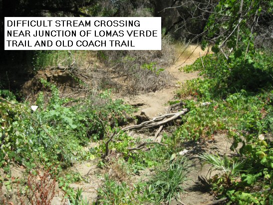
- 03.10 - Turn right on Old Coach Trail and ascend a short, steep hill.
- 04.05 - The trail emerges on Old Coach Rd. Turn right and follow
the road. A trail along the other side is signed as Justins Trail;
you may ride on it if you prefer.
- 04.64 - Justins Trail turns away from the road. Stay on Old Coach Rd.
- 04.67 - The Old Coach Trailhead on the right offers parking,
interpretive signs and a picnic table.
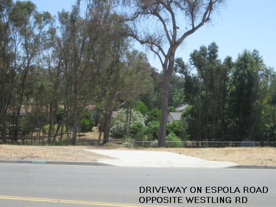
- 04.93 - Turn right on Espola Rd.
- 05.03 - At the corner of Westling Rd. cross Espola Rd. carefully
and enter what looks like a driveway.
- 05.12 - Just before a gate marked as belonging to the
San Diego County Water Authority, turn left into
an obvious but unmarked single track.
- 05.40 - Cross Sage Rd.
- 05.60 - The trail emerges on Espola Rd. Turn right.
You may ride in the bike lane or on a trail parallel to the road.
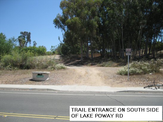
- 05.90 - Turn left on Lake Poway Rd. There is a traffic light here
with button-operated pedestrian/equestrian crossings that you can use.
- 06.02 - Turn right into a dirt road, marked only by a closed area sign and a cylindrical
structure.
- 07.06 - Pass another, larger, cylindrical structure. The trail
continues down a steep hill, but you may prefer to ride on a narrow,
paved access road to the left of it.
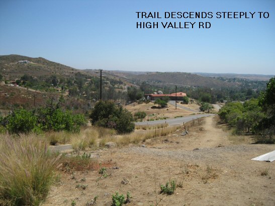
- 07.14 - Turn right on High Valley Rd. Crocker Road, opposite the
trailhead, is not open to the public at this time.
- 07.38 - Cross Espola Rd. at a traffic light and enter Del Poniente Rd.
- 07.63 - Turn right into the signed Del Poniente Trail.
- 07.87 - The trail turns left. There is an informal connection to
an east-west road to the north (probably Northcrest Lane).
- 08.09 - At a four-way trail junction, continue roughly straight ahead
(due west) on Del Poniente Trail. The north-south trail is apparently
Avocado Trail Link, but it is not signed here.
- 08.24 - Cross Midland Road and El Camino Entrada.
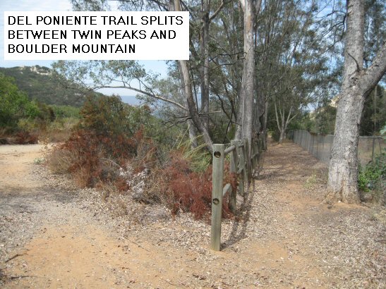
- 08.87 - The trail splits. Keep left and continue roughly due west.
The right branch goes the same place, but it is much less traveled and
may be overgrown. Side trails to the left go toward Twin Peaks, but
the peaks are probably not accessible.
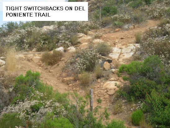
- 09.00 - Del Poniente Trail reaches its highest point. Enjoy the view, and
then continue due west and downhill. Ride with care, because this part
of the trail is steep, eroded and rocky in some places.
- 09.18 - Descend along some small, tight switchbacks and cross a
stream bed, which is usually dry or almost dry.
- 09.33 - Keep right and ride around the edge of a residential area. (The
trail straight ahead goes into the residential area.)
- 09.63 - Just before entering the Pomerado Hospital parking lot, turn right.
(The trail straight ahead emerges in the southeast corner of the parking lot.)
- 09.78 The trail splits. Take the left branch. The right branch apparently
goes the same place, although it has not been surveyed.
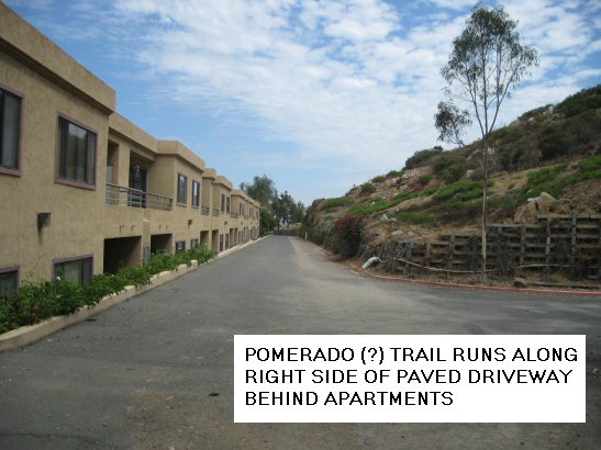
- 09.92 - The trail emerges on a paved driveway behind an apartment complex.
Turn right and follow the trail, which runs right next to the driveway.
- 10.06 - Turn right into a narrow trail. Follow
it downhill and approximately west until it emerges on Pomerado Road near the
intersection with Bernardo Heights Parkway. Somewhere back there, the trail
became Pomerado Trail.
- 10.18 - Turn right and ride north in the bike lane on the east side of
Pomerado Road.
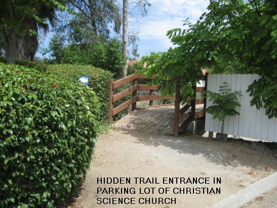
- 10.80 - At the north end of the parking lot for the First Church of Christ
Scientist, cross a small bridge and follow a dirt road north, crossing Avenida
La Valencia.
(If you miss the bridge, turn right on Avenida La Valencia, go
one-half block east, and turn left onto the dirt road.)
- 10.95 - The road turns right and narrows to a path. Follow it along the
a eucalyptus-lined stream, which usually has water in it.
- 11.35 - The trail turns left.
- 11.39 - Turn right into a side trail. (The trail straight ahead goes
directly up to Espola Rd.)
- 11.42 - Cross Avenida La Florencia.
- 11.46 - Turn left to follow a sign toward Green Valley Trails.
- 11.68 - Turn left on Valle Verde Rd. There is no trail sign here, but you can see Valle
Verde Park and a traffic light on Espola Rd
- 11.77 - End of ride at Valle Verde Park.
Return to home page