|
|
Bicycling on Old U.S. 80 in San Diego County |
Please e-mail comments, corrections and additions to the webmaster at pje@efgh.com.
Background | Directions for Eastbound Bicyclists | Directions for Westbound Bicyclists
Bicyclists traveling between San Diego and points east have essentially only one route to follow: Old U.S. Highway 80. Although it has been replaced by Interstate 8, most of the old highway remains and is especially suitable for bicycle travel, especially in rural areas, since Interstate 8 has siphoned off most of the traffic.
The route described here (and the accompanying maps, when available) follows Old U.S. Highway 80 fairly closely, except at the westernmost end, where Highway 80 ended in the middle of downtown San Diego. Because of heavy traffic, most bicyclists prefer to avoid the downtown area whenever possible.
Return to home page
Directions for Eastbound Bicyclists
Numbers indicate approximate distances, in miles, from the beginning of the route.
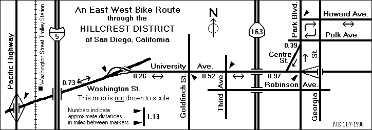
00.00 - Start at Washington Street where Pacific Highway crosses over it. Go east on Washington Street.
Cross the railroad and trolley tracks. The Washington Street Trolley Station is just a short distance to the north on the east side of the tracks.
00.15 - Pass under Interstate 5.
Washington Street and El Cajon Blvd. together form the simplest route east through San Diego. However, the traffic on these streets is fast and heavy, and there is really not much room for bicyclists. I have ridden along these streets, but I don't recommend it. The route described here avoids most of the heavy traffic.
00.73 - Near the top of the first hill, take the University Ave. exit.
00.99 - Cross Goldfinch St. (which is marked as a north-south bike route).
01.51 - Cross Third Ave. (which is marked as a north-south bike route).
Follow University Ave. through the Hillcrest district of San Diego. Although the traffic is heavy through here, it usually doesn't go very fast. It's also a fairly popular bike route, although only the part west of Third St. is marked as such.
The accompanying map shows an alternate route through Hillcrest. You can turn right on Third Ave., left on Robinson St., left on Georgia St. and right on Howard Ave. This route avoids most of the traffic, but it is slightly longer, and it does have some hills. The route described below is almost flat.There are restricted-turn signs on the ramps leading up to the Georgia St. bridge over University Ave. that make them inconvenient for law-abiding bicyclists.
01.91 - Cross over Highway 163.
02.48 - Turn left onto Park Blvd.
02.87 - Turn right onto Howard Ave., which is a signed bike route.
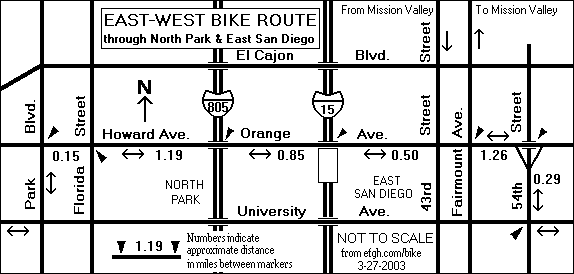
03.02 - Cross Florida St. (which is marked as a north-south bike route).
03.82 - Cross 30th St.
04.21 - Howard Ave. becomes Orange Ave. when it passes over Interstate 805.
05.06 - Cross 40th St. and Interstate 15.
05.56 - Cross Fairmount Ave. (which is a major north-south bike route).
Ascend a very steep hill (about 16%). Fortunately, the hill is only a block and a half long!
06.58 - Cross 52nd St. at the top of the hill.
06.82 - Orange Ave. passes over 54th Street. Just before this bridge, turn right into 54th Street SOUTH.
07.11 - Turn left onto University Ave.
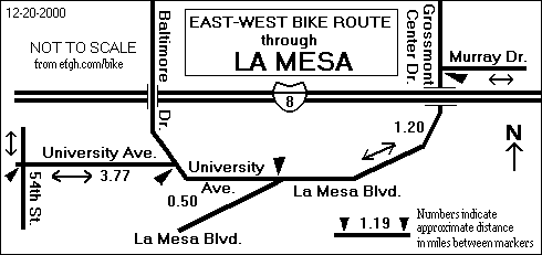
09.06 - Enter the City of La Mesa near the intersection of 69th Street.
10.88 - Turn right to stay on University Ave. (Left would be Baltimore Dr.)
11.01 - Cross the trolley tracks and Spring St. (The Spring St. Trolley Station is a short distance to the right.)
11.38 - University Ave. merges with La Mesa Blvd. Continue straight ahead on La Mesa Blvd.
12.40 - La Mesa Blvd. becomes Grossmont Center Dr. as it passes under Interstate 8.
12.58 - Turn right onto Murray Dr.
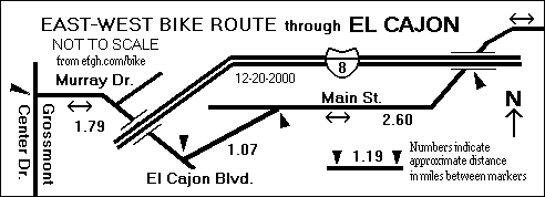
Pass under Highway 125.
13.83 - Go straight ahead onto El Cajon Blvd. (Murray Dr. turns left.) Pass over the trolley tracks and descend into the City of El Cajon.
14.37 - Pass under Interstate 8 and turn left to stay on eastbound El Cajon Blvd.
15.44 - El Cajon Blvd. veers slightly to the right and becomes Main St. (which is also signed as W. Main St. or E. Main St.).
16.04 - Pass Avocado Ave.
17.30 - Cross Highway 54 business loop. Second Ave. is to the left, Jamacha Rd. is to the right. Go straight ahead.
18.04 - Pass under Interstate 8.
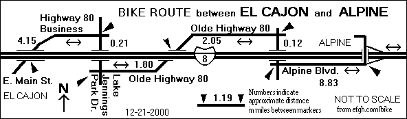
19.55 - Leave the City of El Cajon near Lavala Ln. E. Main St. becomes Highway 80 Business.
20.48 - Cross Los Coches Rd.
22.19 - Turn right on Lake Jennings Park Dr.
Pass under Interstate 8.
22.40 - Turn left onto Olde Hwy 80. (Straight ahead would be Ridge Hill Rd.)
24.20 - Pass under Interstate 8.
26.25 - Turn right onto Alpine Blvd. (Straight ahead would be Chocolate Summit Dr. To left would be Dunbar Lake.)
Pass under Interstate 8.
26.37 - Turn left to stay on Alpine Blvd. (Straight ahead would be Viewside Lane, which is not a through street.)
As you enter Alpine, climb slowly up the first major hill of the route.
An alternate route will take you past the Viejas Casino and Factory Outlet. Turn left at the first overpass and follow Willows Road along the north side of Interstate 8. At the east end of Willows Road, cross Interstate again and enter the Interstate 8 EAST ramp. Although this is the official bike route, it is not favored by bicyclists because the traffic is heavy and the ascent at the east end is significant.
35.20 - When you can go no farther (because the road straight ahead is a rancher's driveway), turn left and then immediately turn right into Interstate 8 EAST. Yes, it is legal to ride on the freeway shoulder here, because there is no reasonable alternative route. This is a fairly significant climb; the grade is as much as six percent, the maximum permitted on most interstate highways.
38.51 - Exit at Japatul Road.
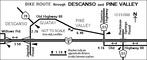
38.78 - At the end of the ramp, turn left onto Highway 79.
40.10 - Pass through Descanso, where limited services are available.
41.54 - Pass the Highway 79 cutoff and continue straight ahead on Old Highway 80. Mile markers begin here. The climb to Guatay will soon begin.
44.08 - Pass through Guatay, where limited services are available. Start descending into Pine Valley.
45.01 - Pass Pine Creek Trailhead. A 0.45-mile paved road leads to the parking area, where primitive rest rooms are available.
46.58 - Pass Pine Valley Rd. Pine Valley County Park is to the left. Rest rooms and drinking water are available, but the park is open only from 9:30 AM to 5:00 PM. At other times it is locked and inaccessible. Enter downtown Pine Valley, where food, water and lodging are available.
46.96 - Leave downtown Pine Valley and begin a fairly significant climb to Laguna Summit.
48.02 - Turn right at a stop sign onto San Diego County Highway S1, which is still Old Highway 80. (The road to the left is Sunrise Highway.) Cross a cattle guard and Interstate 8, and then continue straight ahead. At slightly over 4000 feet above sea level, this is one of the the high points of the ride. A sign on Interstate 8 marks this as Laguna Summit.
The road from here to the Imperial County line is older and the pavement is rather rough in most places. However, the traffic is light.
48.35 - Cross another cattle guard. Begin a fairly long descent to Buckman Springs Road.
52.18 - Cross Buckman Springs Road at a four-way stop with flashing lights. County Highway S1 goes to the right. To the left, between the eastbound and westbound lanes of Interstate 8, is a rest area with restrooms and drinking water. Continue straight ahead on Old Highway 80.
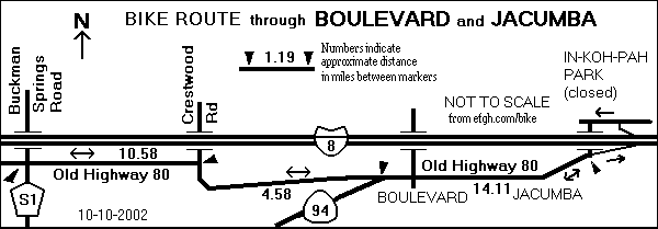
54.32 - Pass Boulder Oaks Campground. Begin a moderate ascent and descent to Kitchen Creek Road.
55.40 - Pass Kitchen Creek Road.
56.63 - Pass the La Posta Diner and Minimart. The diner is open from 6 AM to 10 PM. Begin a fairly significant climb.
58.20 - Pass La Posta Road (to the right) and La Posta Truck Trail (to the left).
58.34 - Leave Cleveland National Forest.
62.76 - Turn right at a stop sign to stay on Old Highway 80. To the left is Crestwood Road and an interchange with Interstate 8. Services available at the nearby Golden Acorn Casino.
64.62 - Pass Live Oak Springs Resort. Restaurant. Deli and market open 24 hours a day.
66.45 - Pass Tierra del Sol Rd. This is the Tecate Divide, 3890 feet above sea level, the other high point of the ride. It's mostly downhill for the next 3.5 miles.
67.34 - Highway 94 joins from the right. Continue straight ahead and enter Boulevard, where food, water and lodging are available. This part of the road is signed as Highway 94.
67.96 - Highway 94 goes off to the left. Go straight ahead on Old Highway 80.
69.87 - Pass McCain Valley Rd.
70.16 - Leave Boulevard.
70.68 - Enter Bankhead Springs. There are no services, because this town has been almost completely abandoned. The road through Bankhead Springs is all uphill.
71.83 - Leave Bankhead Springs. The next 4.5 miles are mostly downhill.
75.21 - Cross a railroad on a bridge built in 1931.
75.46 - Enter Jacumba near mile marker 34.
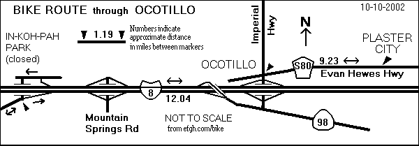
75.91 - Pass Railroad Street and the Jacumba business district. Food, water and lodging are available. Stock up. The next business district is down in the desert in the town of Ocotillo, approximately 17 miles ahead.
76.32 - Leave Jacumba.
77.26 - Pass the entrance to Jacumba Airport. The airport is used very little, and the entrance is usually locked. The next 3 miles are mostly uphill.
77.83 - Pass Carrizo Gorge Rd. There are two gas stations about a mile and a half north on Carrizo Gorge Rd. near Interstate 8.
80.68 - Pass near the brake inspection area on I-8. There is a barbed-wire fence between the inspection area and this road. Start descending, and try to control your speed. Some of the pavement ahead is fairly rough.
81.45 - Enter Interstate 8 EAST. Yes, it is legal to ride on the freeway shoulder here, because there is no reasonable alternative route. Prepare for an 11-mile descent into the Imperial Valley, about 2000 feet lower than this point. That's an average grade of 3.4 percent; the steepest parts are about 6 percent.
CAUTION: The Imperial Valley gets extremely hot in the summer. Much of the rest of the route passes through rural and desert areas with very few services.
You might want to make a SIDE TRIP to the Desert View Tower. Instead of entering Interstate 8, turn left, go under Interstate 8 and then turn right onto In-Ko-Pah Park Road. Follow it about 1.28 miles, mostly downhill. The tower is open every day from 8:30 AM to 5:00 PM. Admission costs 50 cents. Bottled water and canned soft drinks are available. Return via the same route.
81.60 - Enter Imperial County for the first time. The freeway meanders back and forth across the county line for 2.71 miles before it enters Imperial County for the last time.
84.57 - Pass the Mountain Springs Rd exit. Stay on Interstate 8. There are absolutely no services at this exit. Technically, you are supposed to leave the freeway and re-enter. This is not necessary, but be very, very careful when crossing the exit and entrance ramps. Automobile drivers will not be expecting you to do that!
85.42 - Pass the Runaway Truck Ramp.
91.55 - Pass the California Highway 98 Calexico exit. Be very, very careful when crossing the exit ramp. Automobile drivers will not be expecting you to do that!
UPDATE: Bicycles are no longer allowed on Interstate 8 between Highway 98 and Ocotillo. You must exit here and proceed about two miles along Highway 98. Turn left onto Imperial County Highway S2, cross over some railroad tracks, and rejoin the route at mile 93.17.
93.17 - Leave Interstate 8 at the Ocotillo, Imperial Hwy exit.
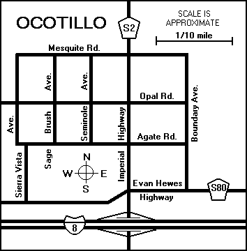
93.37 - At the end of the ramp, turn left onto Imperial County Highway S-2 and pass under Interstate 8 into the town of Ocotillo, where food, water and lodging are available.
93.49 - Turn right onto Imperial County Highway S-80 toward Coyote Wells and Plaster City. This used to be U.S. Highway 80; it is now called Evan Hewes Highway or Evan Hewes Road. The pavement is old and rather rough in most places. If you are riding a road bicycle, you will probably have to slow down a bit. Motor vehicle traffic is fairly light.
97.02 - Cross a bridge and start climbing a small hill. About 0.1 mile to the right, you can see an older Highway 80 which is no longer in use. It runs parallel to this road for 3.75 miles.
97.69 - Enter Plaster City OHV (off-highway vehicle) Area. Watch for dune buggies and other strange motorized vehicles.
101.23 - Pass Plaster City West Staging Area.
102.72 - Pass the headquarters of USG (United States Gypsum Company) in Plaster City. There are no services here, but emergency help might be available at the truck driver's information center next door.
102.97 - Cross a railroad track.
104.23 - Pass Plaster City East Staging Area.
105.87 - Leave Plaster City OHV (off-highway vehicle) Area.
105.97 - Pass Dunaway Road.
107.33 - Pavement gets better!
107.50 - Pass Brown Road, which leads to a state prison. Do not pick up hitchhikers!
107.68 - Pass over the Westside Main Canal.
111.80 - Pass over the New River. Avoid contact with the river water. It carries most of Mexicali's sewage and is badly polluted.
112.45 - Cross Haskell Road in Seeley. There is a small market at this corner.
113.45 - Cross railroad track.
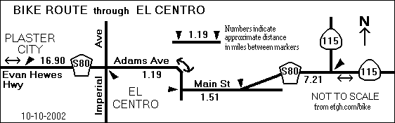
118.66 - Enter El Centro, the largest city in Imperial County. This road becomes Adams Ave. but it is still Imperial County Highway S-80.
119.62 - Cross Imperial Ave. There are a number of motels along the next mile of Adams Ave.
120.81 - Turn left at a traffic light onto Main St. toward Holtville. Main St. is still Imperial County Highway S-80.
120.91 - Cross three railroad tracks.
122.32 - The road swerves to the left and once again becomes Evan Hewes Highway.
122.84 - Leave El Centro. The next business district is in Holtville, about eight miles ahead.
123.88 - Cross California Highway 111. Just ahead, the road becomes a divided highway with ample shoulders -- and a 65 MPH speed limit!
129.53 - Imperial County Highway S-80 ends. Continue straight ahead on southbound California Highway 115.
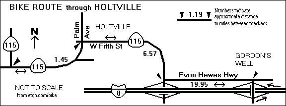
130.59 - Cross the Alamo River and enter Holtville.
130.84 - Keep left to follow Highway 115. This road becomes Palm Ave.
130.98 - Turn right onto W. Fifth St. to follow Highway 115.
131.13 - Pass Holt Park in downtown Holtville. Stop here for supplies. The next business district is more than 40 miles ahead. There is a small restaurant on Evan Hewes Highway near the Gordon's Well interchange, but I have no information about its hours of operation.
131.78 - Leave Holtville on southbound Highway 115.
137.55 - Just before coming to Interstate 8, turn left onto Evan Hewes Highway.
138.56 - Cross the East Highline Canal.
138.65 - Pass the Hot Spring Long-Term Visitor Area. There are some toilets on the south side of the road.
From here to Gordon's Well, the pavement is old and rough, but you should be able to maintain a reasonable speed, even on a road bike. Traffic is extremely light because almost all the cars are on Interstate 8, which runs parallel to Evan Hewes Highway and quite close to it. You will be able to see most of signs for eastbound traffic. There are also a few emergency call boxes on the north side of Interstate 8 that you might have to use. There is a barbed-wire fence between Evan Hewes Highway and Interstate 8, but it is full of holes, especially near call boxes.
140.08 - About here, there is a short stretch of especially bumpy pavement.
149.85 - Interchange between Interstate 8 and Highway 98. Continue straight ahead on Evan Hewes Highway.
152.87 - Interchange between Interstate 8 and Brock Research Center Road. Continue straight ahead on Evan Hewes Highway.
153.44 - Cross a small irrigation canal.
157.29 - Entrance to Pair-a-Dice Restaurant. Hours of operation are not posted, but the restaurant is popular with the dune buggy crowd and should be open on weekends.
157.50 - Turn right and cross over Interstate 8 at the Gordon's Well interchange. NOTE: If you miss this turn, you won't go far astray. Evan Hewes Highway ends about a half mile further east at Gordon's Well Trash Station.
157.66 - Turn left into eastbound Interstate 8. Yes, it is legal to ride a bicycle on the freeway here because there is no reasonable alternative route unless you want to hitch a ride on a dune buggy. For the next eight miles, you will be riding through a sandy area called the Sand Hills, the Imperial Dunes, or the Algodones Dunes.
Keep to the right side of the freeway shoulder. The left side is milled and uncomfortable to ride on.
158.10 - Cross the All American Canal for the first time.
162.32 - Rest area with rest rooms (but no other services) at the left. Do NOT cross the lanes of traffic to enter the rest area. There are better rest rooms at the next exit.
162.55 - Grays Well Road exit. Rest rooms and a public telephone are available at this exit. Strictly speaking, you're supposed to exit here, make a U-turn at the end of the ramp, and re-enter eastbound Interstate 8. However, this is not really necessary. You can stay on Interstate 8, but be very, very careful when crossing the exit and entrance ramps. Automobile drivers will not be expecting you to do that!
163.78 - Cross the All American Canal for the second time.
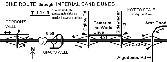
165.55 - Leave Interstate 8 at Ogilby Rd. You must exit here because bicycles are prohibited on the next stretch of Interstate 8.
165.84 - Turn left at the end of the exit ramp onto northbound Ogilby Road, which is also Imperial County Highway S34. Cross over to the north side of Interstate 8.
166.09 - Turn right onto eastbound Center of the World Dr. (formerly signed as Sidewinder Road, and shown on some maps as part of Evan Hewes Highway). The pavement on this road is of inconsistent quality. In some places it's fairly smooth; in other places it's as lumpy as Even Hewes Highway.
170.41 - The Center of the World Plaza, just north of Center of the World Drive, has a small restaurant.
171.00 - Turn right onto Sidewinder Road and cross over Interstate 8.
171.20 - Turn left into eastbound Interstate 8. Yes, it is legal to ride on the freeway shoulder here, because there is no reasonable alternative route.
171.97 - Pass an agricultural inspection station. The station on the south side is apparently closed and abandoned.
173.02 - Exit at Algodones Road. You must exit here because bicycles are prohibited on the next stretch of Interstate 8.
173.23 - Turn left at the end of the exit ramp onto Araz Road, cross over Interstate 8 and continue straight ahead. The pavement is a little rough for the next 4.51 miles.
174.18 - Cross the All American Canal for the third and last time.
177.74 - Swerve to the right, and turn left at a stop sign to continue on eastbound Winterhaven Drive more or less the way you were going.
178.49 - Pass through a small business district in the town of Winterhaven.
179.00 - Pass Imperial County Highway S24 and continue straight ahead.
ALTERNATE ROUTE: Turn left onto Imperial County Highway S24 and then turn right before passing under the railroad tracks. This road leads to an old one-lane bridge over the Colorado River and into Yuma on First Street. Traffic lights at each end of the bridge allow traffic in one direction at a time. There are also pedestrian walkways on both sides of the bridge.
179.34 - Cross over Interstate 8 and continue on Fourth Avenue.
179.51 - Cross over the Colorado River into Yuma, Arizona, and pass from the Pacific Time Zone to the Mountain Time Zone. If Daylight Saving Time is not in effect, set your watch one hour AHEAD (later) to Mountain Standard Time. If Daylight Saving Time is in effect in California, there is no time change because Arizona does not have Daylight Saving Time.
Return to home page
Directions for Westbound Bicyclists
The westbound route is more or less the opposite of the eastbound route. The mileages listed here are not as accurate, because mileages were actually measured only in the westbound direction.
0.00 - Ride north on Fourth Ave., cross over the Colorado River into Winterhaven, California.Yuma, Arizona, and pass from the Mountain Time Zone to the Pacific Time Zone. If Daylight Saving Time is not in effect, set your watch one hour BACK (earlier) to Pacific Standard Time. If Daylight Saving Time is in effect in California, there is no time change because Arizona does not have Daylight Saving Time.
If you want to take the alternate route along the one-lane bridge over the Colorado River, start by riding north on First Street. It curves to the left to reach the bridge. After crossing the bridge, turn left.
0.17 - Cross over Interstate 8 and continue on Winterhaven Dr.
0.51 - Pass Imperial County Highway S24 and continue straight ahead.
1.02 - Pass through the Winterhaven business district.
1.77 - Turn right on Araz Rd. The road immediately swerves to the left, continues more or less the way you were going.
5.33 - Cross the All American Canal for the first time.
6.28 - Turn right onto westbound Interstate 8. Yes, it is legal to ride on the freeway shoulder here, because there is no reasonable alternative route.
Keep to the right side of the freeway shoulder. The left side is milled and uncomfortable to ride on.
7.54 - Pass through a California agricultural inspection station.
8.31 - Exit Interstate 8 at Sidewinder Road. Turn right and then left to follow Center of the World Drive on the north side of Interstate 8. This road was formerly signed as Sidewinder Road, and is shown on some maps as part of Evan Hewes Highway. The pavement on this road is of inconsistent quality. In some places it's fairly smooth; in other places it's lumpy.
9.10 - The Center of the World Plaza, just north of Center of the World Drive, has a small restaurant.
13.67 - Cross over Ogilby Road, which is also Imperial County Highway S34, and enter westbound Interstate 8. Yes, it is legal to ride a bicycle on the freeway here because there is no reasonable alternative route unless you want to hitch a ride on a dune buggy. For the next eight miles, you will be riding through a sandy area called the Sand Hills, the Imperial Dunes, or the Algodones Dunes.
15.73 - Cross the All American Canal for the second time.
16.96 - Grays Well Road exit. Rest rooms and a public telephone are available at this exit. Strictly speaking, you're supposed to exit here, make a U-turn at the end of the ramp, and re-enter westbound Interstate 8. However, this is not really necessary. You can stay on Interstate 8, but be very, very careful when crossing the exit and entrance ramps. Automobile drivers will not be expecting you to do that!
21.41 - Cross the All American Canal for the third and last time.
21.85 - Exit Interstate 8 at Gordons Well. Turn right and then left and follow Evan Hewes Highway west.
22.22 - Entrance to Pair-a-Dice Restaurant. Hours of operation are not posted, but the restaurant is popular with the dune buggy crowd and should be open on weekends.
From here to Highway 115, the pavement is old and rough, but you should be able to maintain a reasonable speed, even on a road bike. Traffic is extremely light because almost all the cars are on Interstate 8, which runs parallel to Evan Hewes Highway and quite close to it. You will be able to see most of signs for westbound traffic. There are also a few emergency call boxes on the north side of Interstate 8 that you might have to use. There is a barbed-wire fence between Evan Hewes Highway and Interstate 8, but it is full of holes, especially near call boxes.
26.07 - Cross a small irrigation canal.
26.64 - Interchange between Interstate 8 and Brock Research Center Road. Continue straight ahead on Evan Hewes Highway.
29.66 - Interchange between Interstate 8 and Highway 98. Continue straight ahead on Evan Hewes Highway.
39.43 - About here, there is a short stretch of especially bumpy pavement.
40.86 - Pass the Hot Spring Long-Term Visitor Area. There are some toilets on the south side of the road.
40.95 - Cross the East Highline Canal.
41.96 - Next to an interchange with Interstate 8, turn right onto Highway 115. CAUTION: There is no street sign at the corner.
47.73 - Enter Holtville on northbound Highway 115.
48.38 - Pass Holt Park in downtown Holtville.
48.53 - Turn left onto Palm Ave. to follow Highway 115.
48.92 - Cross the Alamo River and leave Holtville. Just ahead, the road becomes a divided highway with ample shoulders -- and a 65 MPH speed limit!
49.98 - Go straight ahead to Imperial County Highway S-80 ends. (California Highway 115 turns right.)
56.67 - Enter El Centro, the largest city in Imperial County.
57.19 - The road swerves to the right and becomes Main St., but it is still Imperial County Highway 80.
58.60 - Cross three railroad tracks.
58.70 - Turn right to Adams Ave. at a traffic light to stay on Imperial County Highway S-80. There are a number of motels along the next mile of Adams Ave.
59.89 - Cross Imperial Ave.
60.85 - Leave El Centro. This road is no longer Adams Ave., but it is still Imperial County Highway S-80.
66.06 - Cross railroad track.
67.06 - Cross Haskell Road in Seeley. There is a small market at this corner.
67.71 - Pass over the New River. Avoid contact with the river water. It carries most of Mexicali's sewage and is badly polluted.
71.83 - Pass over the Westside Main Canal.
72.01 - Pass Brown Road, which leads to a state prison. Do not pick up hitchhikers!
73.54 - Pass Dunaway Road.
73.64 - Enter Plaster City OHV (off-highway vehicle) Area. Watch for dune buggies and other strange motorized vehicles.
75.28 - Pass Plaster City East Staging Area.
76.54 - Cross a railroad track.
76.79 - Pass the headquarters of USG (United States Gypsum Company) in Plaster City. There are no services here, but emergency help might be available at the truck driver's information center next door.
78.28 - Pass Plaster City West Staging Area.
81.82 - Enter Plaster City OHV (off-highway vehicle) Area.
86.02 - Turn left on Imperial County Highway S2. This is the town of Ocotillo, where food, water and lodging are available.
86.14 - Turn right into westbound Interstate 8. Yes, it is legal to ride a bicycle on the freeway here because there is no reasonable alternative route.
UPDATE: Bicycles are no longer allowed on Interstate 8 between Ocotillo and Highway 98. Continue south on Imperial County Highway S2, turn right on California Highway 98 and follow it onto westbound Interstate 8 at mile 87.96. The warning given below does not apply.
87.96 - Be very careful while passing the onramp from California Highway 98. There is no exit here, so you cannot exit and re-enter. But motorists entering Interstate 8 here will not be looking for bicyclists!
In the 11-mile ascent out of the Imperial Valley, extra care is required when crossing two bridges with rather narrow shoulders.
94.94 - Pass the Mountain Springs Rd exit. Stay on Interstate 8. There are absolutely no services at this exit. Technically, you are supposed to leave the freeway and re-enter. This is not necessary, but be very, very careful when crossing the exit and entrance ramps. Automobile drivers will not be expecting you to do that!
97.56 - Leave Interstate 8 at the In-Koh-Pah Park Road exit. Turn left at the end of the exit.
You might want to make a SIDE TRIP to the Desert View Tower. Instead of turning left here, turn right. Follow In-Ko-Pah Park Road about 1.28 miles, mostly downhill. The tower is open every day from 8:30 AM to 5:00 PM. Admission costs 50 cents. Bottled water and canned soft drinks are available. Return via the same route.
98.06 - Turn left and cross over Interstate 8.
101.68 - Pass Carrizo Gorge Rd. There are two gas stations about a mile and a half north on Carrizo Gorge Rd. near Interstate 8.
102.25 - Pass the entrance to Jacumba Airport. The airport is used very little, and the entrance is usually locked. The next 3 miles are mostly uphill.
103.19 - Enter Jacumba.
103.60 - Pass Railroad Street and the Jacumba business district. Food, water and lodging are available.
104.05 - leave Jacumba near mile marker 34.
104.30 - Cross a railroad on a bridge built in 1931.
107.68 - Enter Bankhead Springs. There are no services, because this town has been almost completely abandoned. The road through Bankhead Springs is all downhill.
108.83 - Leave Bankhead Springs.
109.35 - Enter Boulevard.
109.64 - Pass McCain Valley Rd.
111.55 - Highway 94 goes off to the right. Go straight ahead on Old Highway 80. Food, water and lodging are available.
112.17 - Highway 94 veers to the left. Continue straight ahead toward San Diego.
113.06 - Pass Tierra del Sol Rd. This is the Tecate Divide, 3890 feet above sea level, one of the highest points of the ride.
114.89 - Pass Live Oak Springs Resort. Restaurant. Deli and market open 24 hours a day.
116.75 - Turn left to stay on Old Highway 80. The road straight ahead goes under Interstate 8 and becomesis Crestwood Road. Services are available at the nearby Golden Acorn Casino.
121.17 - Enter Cleveland National Forest.
121.31 - Pass La Posta Road (to the left) and La Posta Truck Trail (to the right).
122.88 - Pass the La Posta Diner and Minimart. The diner is open from 6 AM to 10 PM.
124.11 - Pass Kitchen Creek Road.
125.19 - Pass Boulder Oaks Campground, which is permanently closed.
127.33 - Cross Buckman Springs Road at a four-way stop with flashing lights. County Highway S1 goes to the left. To the right, between the eastbound and westbound lanes of Interstate 8, is a rest area with restrooms and drinking water. Continue straight ahead on Old Highway 80.
131.16 - Cross a cattle guard.
131.49 - Cross over Interstate 8, cross another cattle guard, and turn left into Old Highway 80. (The road straight ahead is Sunrise Highway.) At slightly over 4000 feet above sea level, this is one of the the high points of the ride. A sign on Interstate 8 marks this as Laguna Summit.
132.55 - Enter Pine Valley. Food, water and lodging are available here.
132.93 - Pass Pine Valley Rd. Pine Valley County Park is to the right. Rest rooms and drinking water are available, but the park is open only from 9:30 AM to 5:00 PM. At other times it is locked and inaccessible.
134.50 - Pass Pine Creek Trailhead. A 0.45-mile paved road leads to the parking area, where primitive rest rooms are available.
135.43 - Pass through Guatay, where limited services are available. Start descending into the Descanso Valley.
137.97 - Highway 79 is to the right and straight ahead. Continue straight ahead on Highway 79.
139.41 - Pass through Descanso, where limited services are available.
140.73 - Turn right into westbound Interstate 8. Yes, it is legal to ride a bicycle on the freeway here because there is no reasonable alternative route.
144.31 - Leave Interstate 8 at the East Willows exit. Turn left at the end of the ramp, cross over Interstate 8, and turn right onto Alpine Blvd.
An alternate route will take you past the Viejas Casino and Factory Outlet. Turn right at end of the ramp and follow Willows Road along the north side of Interstate 8. At the west end of Willows Road, cross Interstate again and turn right onto Alpine Blvd. Although this is the official bike route, it is not favored by bicyclists because the traffic is heavy.
Alpine is a fairly large community; many goods and services are available along Alpine Blvd.
153.14 - Turn right and go under Interstate 8. (Left would be Viewside Lane, which is not a through street.)
153.26 - Turn left onto Old Highway 80, sometimes called Highway 8 Business. (Straight ahead would be Dunbar Lake Dr. To the right would be Chocolate Summit.)
155.31 - Pass under Interstate 8.
157.11 - Turn right onto Lake Jennings Park Rd. and go under Interstate 8.
157.32 - Turn left on Highway 8 Business.
159.03 - Cross Los Coches Rd.
159.96 - Enter the City of El Cajon near Lavala Ln. This street becomes E. Main St.
161.47 - Pass under Interstate 8.
162.21 - Cross Highway 54 business loop. Second Ave. is to the right, Jamacha Rd. is to the left. Go straight ahead.
163.47 - Pass Avocado Ave.
164.07 - Veer left to El Cajon Blvd. about 0.05 miles beyond Chambers St.
165.14 - Turn right and pass under Interstate 8.
165.68 - Go straight ahead to Murray Dr. (To the right is also Murray Dr.)
Pass under Highway 125.
166.93 - Turn left onto Grossmont Center Dr.
167.11 - Grossmont Center Dr. becomes La Mesa Blvd. as it passes under Interstate 8.
168.13 - La Mesa Blvd. veers left. Go straight ahead to University Ave.
168.50 - Cross the trolley tracks and Spring St. (The Spring St. Trolley Station is a short distance to the left.)
168.63 - Turn left to stay on University Ave. (Straight ahead would be Baltimore Dr.)
170.45 - Enter the City of San Diego near the intersection of 69th Street.
172.40 - Turn right onto 54th St.
172.69 - Turn right to an exit ramp, turn left onto Orange Ave. and pass over 54th Street.
172.93 - Cross 52nd St. and descend a very steep hill, which is only two blocks long.
173.95 - Cross Fairmount Ave. (which is a major north-south bike route).
174.45 - Interstate 15 and 40th St.
175.30 - Orange Ave. becomes Howard Ave. where it passes over Interstate 805.
175.69 - Cross 30th St.
176.49 - Cross Florida St. (which is marked as a north-south bike route).
176.54 - Turn left on Georgia St.
176.74 - Turn right on Polk Ave.
176.84 - Turn left on Park Blvd.
You can cut the next corner by turning right into Centre St. Follow it to its end, and then turn right onto University Ave.
177.03 - Turn right onto University Ave.
177.60 - Cross over Highway 163.
Follow University Ave. through the Hillcrest district of San Diego. Although the traffic is heavy through here, it usually doesn't go very fast. It's also a fairly popular bike route, although only the part west of Third St. is marked as such.
178.00 - Cross Third Ave. (which is marked as a north-south bike route).
178.52 - Cross Goldfinch St. (which is marked as a north-south bike route).
178.78 - Westbound University Ave. merges with westbound Washington St.
179.36 - Pass under Interstate 5.
Cross the railroad and trolley tracks. The Washington Street Trolley Station is just a short distance to the north on the east side of the tracks.
179.51 - End on Washington Street where Pacific Highway crosses over it. Pacific Highway is Old Highway 101, and a major north-south bike route.