|
|
Red Routes
|
 |
 |
 |
Please e-mail comments, corrections and additions to the webmaster at pje@efgh.com.
Orange County, California has a lot of paved bicycle and pedestrian paths, which I call "red routes" because they are shown in red ink on the official path and trail maps.
This list was formerly part of a similar list for San Diego County, but the combined list became unwieldy and had to be split.
Every path has been given a name, but in some cases the name is unofficial.
For brevity, each path is described in only one direction. However, all of these paths are two-way bike paths except where specifically noted otherwise.
All of these paths, except the uncompleted ones, are paved.
This list is not complete, and probably will not be complete for several years to come. I am adding paths from time to time as I explore them.
Philip J. Erdelsky pje@efgh.com
The path begins on the west bank of San Juan Creek near its mouth (Thomas 972 A7, N 33 27.749 W 117 41.060). There is access to the path from the parking lot of Doheny State Beach just west of the creek.
The path runs north for about 0.09 miles and passes under the Pacific Coast Highway. Unfortunately, the underpass was flooded when I first explored it on September 9, 2000. (See photograph.) It is probably always flooded at high tide.
It then runs north along the west bank of San Juan Creek. There is good access to Del Obispo Park, Mission Bell Park, Stonehill Drive, and residential areas along the way. (See photograph.)
Where Trabuco Creek meets San Juan Creek 2.37 miles north of the Pacific Coast Highway (Thomas 972 C3), the path crosses Trabuco Creek on a small bridge and enters Descanso Veterans Park. (See photograph.)
Another bike path (Robert McCollum Memorial Bicycle Trail) runs north along the east bank of Trabuco Creek for 0.95 miles to the south end of Avenida de la Vista (Thomas 972 C1). There is access to both sides of Del Obispo Street.
The main path continues northeast along San Juan Creek, passing under the railroad tracks, under Camino Capistrano and under Interstate Highway 5 to the southwest end of Paseo Tirador. There is good access to both sides of Camino Capistrano.
The path runs along the southeast sides of Paseo Tirador and Calle Arroyo to La Novia Avenue.
On the other side of La Novia Avenue, the path continues. It rejoins Calle Arroyo and runs along its southeast side.
The path ends at the corner of Calle Arroyo and Avenida Siega (Thomas 952 F7, N 33 30.718 W 117 38.003), which is 2.31 miles from Camino Capistrano.
North San Juan Creek Trail, an unpaved path suitable for mountain bikes (and possibly hybrid bikes) runs parallel to this path and between it and San Juan Creek east of La Novia Avenue. There is also a portion west of La Novia Ave., but it goes nowhere except to a few stables along Paseo Tirador, and it is so soft that it is suitable only for horseback riding.
Last explored: 4-19-2013
This two-way path runs along the east side of Rancho Viejo Road from Calle Arroyo (Thomas 972 D1, N 33 30.059 W 117 39.173) to Via Escolar (Thomas 952 B2), which is the entire length of the road.
The path is paved everywhere EXCEPT for a 0.17-mile section from Trabuco Creek Rd. to Village Rd. (Thomas 952 B4). This section is unpaved, but an adjacent sidewalk is paved. Road bicyclists can ride on the sidewalk.
Much more troublesome, especially for southbound bicyclists, is a 0.23-mile gap south of Malaspina Rd. (Thomas 952 C6). In this section, there is no path, not even an unpaved one, and there is no sidewalk. Northbound bicyclists can ride in the road, which has a bike lane in this area. Southbound bicyclists must either switch to the west side and back or ride in the bike lane on the wrong side of the road. Riding through an adjacent parking lot is not recommended; there are signs forbidding it, and the parking lot is not located next to the road.
Bicyclists traveling along Rancho Viejo Road can cross under Interstate Highway 5 to Camino Capistrano (or vice-versa) easily in three places:
Last explored: 4-19-2013
This path runs through a narrow park west of Camino Capistrano and east of the Metrolink railroad tracks between La Zanja St. (Thomas 952 C7) and Calle Chueca (Thomas 952 B6).
Like all roadside bike paths, this path is inconvenient for bicyclists traveling in the wrong direction. Northbound bicyclists must turn left at La Zanja St. to enter the path and then turn left again to leave it at Calle Chueca. This can be difficult when traffic is heavy, especially at Calle Chueca, where there is no traffic light.
Last explored: 4-19-2013
This path runs almost entirely through private property. The City of San Juan Capistrano somehow got an easement for a public right-of-way through a golf course and gated community.
The path begins at the gated entrance to Golf Club Drive on the east side of Rancho Viejo Road (Thomas 952 D7). Bicyclists entering the path here should look for a pedestrian-size gate just south of Golf Club Drive. Signs mark the path as passing through private property, and warn bicyclists of such hazards as golf balls. (Wear your helmet!)
Bicyclists leaving the path here will emerge through similar gate on the other side of Gold Club Drive.
The eastbound path runs along the south side of Golf Club Drive along something that looks like a sidewalk, except for occasional bicycle icons on the pavement. The westbound path runs along a similar sidewalk on the other side of Golf Club Drive. (See photograph.)
At the end of Golf Club Drive, the path turns more or less south and runs along the south side of Marbella Vista. Both directions run along the same sidewalk, but it is a wide sidewalk.
At the end of Marbella Vista, the path enters the Marbella Golf and Country Club and shares a path with golf carts for the next 0.10 mile.
The path then veers left near some restrooms and leaves the golf course. Two unpaved paths, Helicopter Hill Trail to the south and North Hunt Club Trail to the north, intersect this path on the other side of a gate. Only North Hunt Club Trail is signed. These trails are open to bicycles, but they are suitable only for mountain bikes because they are unpaved.
The path continues north and runs along a wide sidewalk on the west side of Horno Creek Road. It ends at the corner of Horno Creek Road and Silver Creek Drive (Thomas 952 E5).
Rancho Line Trail, which is another unpaved path suitable only for mountain bikes, begins on the north side of Silver Creek Drive, just north of Hillside Terrace and just west of a circular corral.
On the west side of Rancho Viejo Road there is a short (0.10 mile) path which might be considered an extension of this path. It leads to a gate at the east end of El Horno Street. The gate is normally locked to prevent the passage of automobiles, but there is an open space north of the gate large enough to ride a bicycle through. El Horno Street passes under Interstate Highway 5.
Last explored: 2-6-2003
CLOSURE NOTICE: The 0.75-mile section of the trail between Jeffery Road and Sand Canyon Ave. is closed till early 2010 while Jeffery Road is being converted to a railroad underpass.
This path begins on the southeast side of Harvard Ave. in Irvine, next to the Metrolink railroad tracks and just southwest of them (Thomas 860 E2). It runs southeast, following the railroad right of way to emerge on Sand Canyon Ave. (Thomas 860 J5) near the railroad tracks.
The path passes over Culver Drive and under Yale Ave. There are signed side paths to both sides of both roads.
The path crosses Jeffrey Road, and meets Harvard Ave. and Sand Canyon Ave., at grade level.
Northwest of Jeffrey Road, the path meanders through a planted or landscaped area. There are a few benches next to the path, and even a drinking fountain, just northwest of Yale Ave.
Small signs next to the path give the names of adjacent residential streets. There is a wall between the path and the residential area to the southwest, but it is pierced by sidewalks or side trails in convenient places.
At the northeast end, a side path of sorts runs along the northwest side of Sand Canyon Ave. southeast as far as Alton Parkway. It resembles a sidewalk in some places, but there are signs marking it as a bike path. Bicyclists can use it to get access to the San Diego Creek Bike Path. However, Sand Canyon Ave. alos has bike lanes in most places.
Last explored: 3-24-2003, closure notice by Noel Keller 3-16-2008
The path then turns right and runs northeast along the southeast side of the Peters Canyon Wash, passing under Walnut Ave., Harvard Ave., Interstate Highway 5 and El Camino Real, and coming to an abrupt end between El Camino Real and Bryan Ave. (Thomas 830 F6). Some day, it may run farther northeast.
UPDATE: The path has been extended, apparently as far as Portola Parkway.
There is formal access to the path from both sides of Walnut Ave., Harvard Ave. and El Camino Real.
The undercrossings are subject to flooding and closure in the rainy season. It was open on March 24, 2003, but there was quite a bit of dirt and sand on the path in some places, and some of the access ramps were closed.
There is another path along the northwest side of Peters Canyon Wash, but not all of it is paved.
There are two side paths into Harvard Community Athletic Park, one of which leads directly to the parking area opposite Poplar Street.
Signs and paving patterns seem to indicate that the portion south of the Poplar Street side path is newer than the northern portion. See photograph.
There are plans to extend the path southwest to join the San Diego Creek Bikeway at or near Col. Bill Barber Memorial Park (Thomas 860 B4).
UPDATE: The path has been extended to the San Diego Creek Bikeway.
This path might be considered an extension of Walnut Trail.
Last explored: 3-24-2003, updates by Noel Keller 12-10-2007
This path runs along the San Diego Creek from Jamboree Road in Newport Beach (Thomas 889 F2) to Interstate Highway 405 near Irvine Center Drive in Irvine (Thomas 861 A2), and perhaps a little farther. The upstream end is currently closed and inaccessible.
The official name of this path, which appears on path markers in various places, is the San Diego Creek Bikeway. However, the upstream end is apparently called the Regional Bike Trail. It is not clear where the name changes.
At the downstream end the path runs along the south bank of the San Diego Creek and passes under Jamboree Road. There is formal access to the west side of Jamboree Road and only informal access to the east side. At this point it joins another path called the Back Bay Trail.
The path runs under all streets and freeways that cross San Diego Creek as far upstream as Lake Road in Irvine (Thomas 860 D5). There is formal access to all cross streets, and all of them are marked by small signs on the sides of the bridges. In most cases, the sign gives not only the name of the street, but also the clearance above the path.
Between Harvard Ave. and Alton Parkway (Thomas 830 B4), the path crosses over the creek and runs along its north bank upstream from this point. There is access to the path from Colonel Bill Barber Memorial Park.
The path crosses Lake Road and Creek Road at grade level and runs under Yale Road and Jeffrey Road. It appears that the path formerly ended at Jeffrey Road next to Windrow Community Park (Thomas 860 F6). A map posted next to the path near the U.C. Irvine campus shows the path going only that far.
The path now runs farther upstream, but you'll have to ride along Jeffrey Road (or the sidewalk) for a short distance to follow the path. The path is no longer signed formally as the San Diego Creek Bikeway, but outdated detour signs on the path on March 24, 2003 used that name.
Upstream from Jeffrey Road, there are paths along both sides of the creek. In most places, one side is preferred because it runs under cross streets instead of crossing them at grade level.
Between Jeffrey Road and Alton Parkway (Thomas 890 J1), it is better to ride on the south side of the creek. Beyond that point, it is better to ride on the north side. The path on the south side has no passage under California Highway 133 (which is a freeway) and comes to an abrupt end in sight of Call Box 133-87T.
The path along the north side passes under California Highway 133 and emerges on a new street which is not on the 2003 Thomas Guide. The path then switches to the south side of the creek and runs under Interstate Highway 405. However, this part of the path is closed and access to it is barred by fences and a locked gate. A sign on the gate describes this section of the path as "extremely dangerous". The levee on the north side of the creek is rough but accessible and ridable; however, it has no passage under Interstate Highway 405.
It seems likely that the path will eventually be reopened and may be extended. Readers in the Irvine area should keep an eye on it.
Photograph of the path in the Woodbridge area.
Last explored: 3-24-2003
This path begins on the west side of Jeffrey Road, next to the ramp from southbound Jeffrey Road to westbound Interstate Highway 405 (Thomas 860 F7). It runs west just north of Interstate Highway 405 and ends at a junction with the San Diego Creek Bike Path (Thomas 860 A6).
Although Interstate Highway 405 runs nearly east and west in this area, most of it runs more nearly north and south. Therefore, westbound ramps are signed as NORTH and eastbound ramps are signed as SOUTH.
Bicyclists emerging from this path onto Jeffrey Road can turn right and go south in a bike lane. However, crossing Jeffrey Road here at grade level is out of the question, so northbound bicyclists must ride on the sidewalk to Alton Parkway, where there is a traffic light and pedestrian crosswalks.
There is a signed connection with the Yale Bike Path; the sign says "YALE AVE SOUTH".
The path crosses Culver Drive at grade level, where there is a traffic light and pedestrian crossing. However, the path on the west side of Culver Drive is easy to overlook, because it is quite narrow and looks very much like a sidewalk, and because there is no sign on it. See photograph.
The path passes under Harvard Ave., but there is good access on both sides of the street.
Last explored: 10-9-2003
Yale Ave. is divided into three separate sections. The two parts of this path connect them. The southern segment is 0.14 miles long and the northern segment is 1.78 miles long.
The path begins at the north end of one segment of Yale Ave. just south of Interstate Highway 405 (Thomas 860 D7). Yale Ave. was apparently severed when the freeway was built. The path passes over the freeway on a pedestrian and bicycle bridge and joins another segment of Yale Ave. on the north side. There is an 0.11-mile side path here leading to the Interstate 405 Bike Path.
The next part of the path begins on the north side of East Yale Loop and runs north near the east side of South Lake (Thomas 860 D7). It turns away from the lake and runs near a street called "Springbrook S", then turns back toward the lake and crosses over Alton Parkway on a pedestrian and bicycle bridge.
It passes through Woodbridge Community Park and crosses the San Diego Creek.
On the north side of the creek, there is an intersection with the San Diego Creek Bike Path.
This path continues north through the Woodbridge Village Shopping Center, running along the edge of the parking lot. It crosses Barranca Parkway on another pedestrian and bicycle bridge and continues north along the west side of North Lake.
The path turns away from the lake to run next to a street called "Stone Creek North" and then turns back toward the lake. It comes to an end on the south side of West Yale Loop near Yale Ave. (Thomas 860 F4).
Last explored: 10-9-2003
This path begins at the downstream end of the San Diego Creek Bikeway on the west side of Jamboree Road in Newport Beach (Thomas 889 F2). In fact, it might be considered a downstream extension of that path. It is signed as "Back Bay Trail".
The path runs south along the west side of Jamboree Road and then west along the north side of Eastbluff Drive. It then follows Back Bay Drive along the shore of Upper Newport Bay. Although the Thomas Guide shows Back Bay Drive as a one-way road, it is a two-way road for bicycles and pedestrians, so it qualifies as at least a semi-red route. Southbound bicyclists get their own lane; northbound bicyclists must share the road with cars. See photograph.
At the intersection with Shellmaker Road (Thomas 889 C6), Back Bay Drive ceases to be one-way, so the red route ends. However, the rest of Back Bay Drive, all the way to Jamboree Road, has bike lanes.
Last explored: 3-24-2003
This path, which is signed merely as a "bike route", begins on the south side of Back Bay Drive, just west of Jamboree Road and east of the entrance to Newport Dunes Resort and Marina (Thomas 889 D7). It runs along the south side of the resort and ends on N. Bayside Drive next to another entrance to the resort (Thomas 889 C7).
Last explored: 3-24-2003
This path follows Aliso Creek for nearly 13 miles through suburban and rural areas of Orange County, running through a number of parks. It is an especially good recreational ride. The path is paralleled in many places by an unpaved equestrian and hiking path.
The path is signed as "Aliso Creek Bikeway" in most places. In many places, it is also signed as "Aliso Creek Path", although this probably refers to the parallel equestrian and hiking path. On Google Earth it is labeled "Aliso Creek Riding and Hiking Trail" in some places.
There is good formal access to the path from adjoining streets and neighborhoods in many places. Side paths are generally as good as the main path, and the places where they emerge are clearly marked, usually with both the name of the path and the name of the street.
Most of the side paths are fairly short. Bicyclists who make a wrong turn will usually discover their mistake quickly. An exception is noted below.
In many places where the path passes under a road it runs so close to Aliso Creek that it may become flooded and impassible when the creek level is high, and there are signs to this effect on the path. In most such places, bicyclists can simply cross at street level, although this may be difficult when motor vehicle traffic is especially heavy. (See photograph.)
Aliso Creek rises in Cleveland National Forest (Thomas 862 G2) and runs roughly south to the ocean (Thomas 951 B7). Bicyclists who want to ride the path in both directions will probably want to ride upstream first, and that is the direction of this description.
The path begins on the north side of Awma Road 0.05 miles west of Alicia Parkway (Thomas 951 E1, N 33 33.127 W 117 43.130). It runs north and east near Aliso Creek except where noted.
About 2.67 miles north of Awma Road (Thomas 921 F4, N 33 35.049 W 117 42.706), this path crosses a small bridge over Aliso Creek and then splits. The right branch was formerly signed as "Alicia Creek Trail". Be sure to turn LEFT at this junction. Alicia Creek is NOT the same as Aliso Creek. If you follow the Alicia Creek Trail, you will find yourself up the wrong creek! However, you will be able to recover from this mistake, because Alicia Creek Trail eventually reaches Paseo De Valencia, where you can turn left and pick up the correct path where Paseo De Valencia crosses Aliso Creek.
About 3.28 miles north of Awna Road, the path runs through Sheep Hills Park (Thomas 921 F3) and splits in two (at N 33 35.521 W 117 42.657). The left branch is just a side path -- it runs next to Aliso Creek and under Laguna Hills Drive to the other side of the street. The main path turns away from Aliso Creek and runs roughly east up Laguna Hills Drive 0.65 miles to Paseo De Valencia. Bicyclists may ride on the sidewalk, which is signed as a path and looks like a piece of the path only at the upper end.
The path turns left and runs roughly north for 0.56 miles along the east side of Paseo De Valencia (which is signed as P.D. Valencia at the intersection).
Just after Paseo De Valencia crosses Aliso Creek, the path turns right and again follows the creek.
It appears that the path had to be routed onto the streets because a right-of-way could not be obtained next to Aliso Creek just west of Paseo De Valencia.
About 0.65 miles north of Paseo De Valencia, the path runs under Interstate Highway 5 next to the creek (Thomas 921 H1, N 33 36.416 W 117 41.689). If this part of the path is flooded, you'll have to find an alternate route, such as Los Alisos Blvd. The path runs along the west side of the creek here, but there is a bridge over to Sycamore Park.
NOTICE: Impaired access to the path from Alicia Parkway due to a bridge washout just south of Interstate Highway 5 was reported on February 22, 2010. No word on when the damage will be repaired. As of August 10, 2013, the side path was still closed.
The passage under Los Alisos Blvd. (Thomas 891 H7) is especially low and flood-prone. In fact, the path here runs right along the bottom of a concrete channel and crosses the creek on a metal plate. (See photograph.)
The path veers away from Aliso Creek to avoid a golf course and rejoins it as it passes under the Metrolink/Amtrak railroad tracks (Thomas 891 J6, N 33 37.360 W 117 41.364).
About 8.73 miles north of the south end, the path passes under El Toro Road (Thomas 892 B2, N 33 38.654 W 117 39.948) and runs roughly northeast on a route parallel to El Toro Road and northwest of it. In many places, it apparently runs along a previous alignment of El Toro Road.
There is a small parking area next to the path just west of Marguerite Parkway (Thomas 862 D7, N 33 39.671 W 117 38.567). Bicyclists who want to ride only the northernmost few miles of the path might want to park here.
Hopefully, you won't need to use it, but there is an emergency call box 767-B3 next to the path about 0.42 miles northeast of the lofty bridges of the Highway 241 toll road.
A short, unpaved side path leads to the McFadden Ranch House (Thomas 862 G5), which is also a convenient rest stop.
About 0.15 miles north of the McFadden Ranch House, the northbound path turns right, passes under El Toro Road, turns left, and runs along the other side of El Toro Road. The path straight ahead goes 0.06 miles to El Toro Road. It is an entrance for southbound bicyclists.
The path comes to an end at the intersection of El Toro Road and Ridgeline Road. (Thomas 862 G4, N 33 40.896 W 117 37.267). Many bicyclists continue on El Toro Road, which becomes Santiago Canyon Road at the next intersection.
Photograph taken near north end. The path is apparently built over an old alignment of El Toro Road.
Last explored: 8-10-2013
For bicyclists riding this path for the first time, it may be hard to find and hard to follow.
The path begins on the east side of the Street of the Golden Lantern approximately opposite Orange County Fire Station 49 (Thomas 971 J1). It runs through a large culvert under Golden Lantern and then swings north to run roughly northwest on the north side of a canyon that is part of the Salt Creek Corridor Regional Park. There is also access from the west side of Golden Lantern.
There are no path signs on either side of the street. However, there is a sign for the Dog Park Parking Area next to the fire station. Path users can park there, follow a short unpaved path to the culvert and enter the path there.
The path descends and emerges on Chapparosa Park Road at the entrance to Chapparosa Park (Thomas 951 J7).
This section is signed internally as Salt Creek Trail, but there are no path signs at the access points.
The path follows Chapparosa Park Road roughly southwest through the park. At the other end of the park, a 0.16-mile side path runs steeply upward to a street called "Parc Vista".
The main path continues roughly west or southwest along the north side of the canyon. It is still signed as Salt Creek Trail.
Shortly before the path meets Niguel Road, it turns sharp right at a rather mysterious sign that says "Anderson". (It might be the name of a street that was abandoned when the path was opened.) Just beyond the turn is a poorly marked path junction. The path continues straight ahead for 0.77 miles to a point on Marina Hills Parkway near Niguel Road. The bike path apparently ends there, but a parallel horse path apparently goes under Marina Hills Parkway and beyond. (This part was last explored in 2003 and was not explored again in 2010.)
The main part of Salt Creek Trail turns left at the junction and passes under Niguel Road to the west side.
On the west side of Niguel Road, there are two more path junctions, both unsigned.
At the first junction, a 0.78-mile side path goes left (south) parallel to Niguel Road as far as Ridgeway Ave.
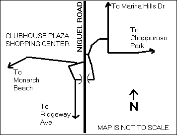
The main path goes right and climbs steeply up toward the Clubhouse Shopping Center and emerges on the west side of Niguel Road. Persons bound for Monarch Beach should turn sharp left at a second junction to follow the main path. The accompanying map may be helpful.
The path continues roughly south along the west side of a canyon and passes under Camino Del Avion. Side paths lead to both sides of the road.
South of Camino Del Avion, a short section of the trail (roughly 400 feet) has suffered from land subsidence and is quite rough. However, on August 10, 2010, it was open and could be ridden with care, even on a road bike.
The trail continues roughly south along the west side of the Monarch Beach Golf Course and turns west to pass under the Pacific Coast Highway. There is access to both sides of the highway, but the access points are hard to find, especially from the highway. Northbound bicyclists looking for the path should stop just north of the golf course.
Just after passing under the Pacific Coast Highway, the path turns left. Other paths lead to parts of the golf course. Watch out for golf carts.
The path finally reaches the ocean and then turns south and runs about 0.26 miles south along the beach. It crosses a narrow access road to a marine life refuge (Thomas 971 E5).
The access road runs under Ritz Carlton Drive to a parking area on the east side.
Official maps show this as the end of the trail, but the path continues for another 0.41 miles, signed as Ritz-Carlton Public Beach Access.
The path narrows considerably as it runs next to Ritz-Carlton hotel buildings, passing something signed as Jean-Michel Cousteau's Outdoor Learning Center, to a set of steps. The trail emerges on the main access road for the Ritz-Carlton Hotel, very close to the Pacific Coast Highway. (Notice that this is not Ritz Carlton Drive.)
This end is also signed as Ritz-Carlton Public Beach Access.
Last explored: 8-10-2010
This path runs along the southwest side of the Pacific Coast Highway from Camino Capistrano (Thomas 992 E2, N 33 26.493 W 117 38.723) to Palisades Dr. (Thomas 972 C7, N 33 27.332 W 117 40.072). It actually consists of a strip of the highway, separated from the rest by K-rails. It looked like a temporary route during work on Pacific Coast Highway, but it has been there for years, and signs at both ends suggest that it is intended to be permament.
The adjacent part of Pacific Coast Highway remains open to bicyles.
The path lies entirely in Dana Point, although the south end is at or near the San Clemente city limit.
The adjacent highway northwest of Camino Capistrano is called Pacific Coast Highway. The part southeast of Camino Capistrano, which lies in San Clemente, is called N. El Camino Real.
Bicyclists bound northwest on N. El Camino Real in San Clemente should use the pedestrian signal at Camino Capistrano to enter this path, as official signs direct.
Bicyclists who intend to follow Pacific Coast Highway northwest all the way to downtown Dana Point are well advised to use this path. At the north end, they should turn left, cross the railroad tracks, and turn right into a small bike path next to the beach. They can then ride through parking lots and access roads through Doheny State Beach all the way to Dana Point Harbor Dr., where they can turn right and rejoin Pacific Coast Highway.
The reason for this detour is that there is no northbound lane through the junction of Pacific Coast Highway and Doheny Park Rd. Motorists can make the connection by driving a short distance on California State Highway 1, where bicycles are prohibited. The only legal way though this intersection is on foot, on the southwest side of Pacific Coast Highway. Pedestrian crossing signals make this a feasible, but very inconvenient, route for bicyclists.
Last explored: 4-19-2013