|
Please e-mail comments, corrections and additions to the webmaster at
pje@efgh.com.
Red Routes in San Diego County
Many streets and highways in San Diego County have bike lanes. There
are also a number of
bike paths, which are paved roadways reserved for non-motorized
travel. I call them "red routes", and I've compiled a fairly complete list.
Click here to see the list.
Free Map of Bike Routes
SANDAG (San Diego County Association of Governments) publishes a map
of San Diego County that shows all officially recognized bike routes.
The map is free; download it or order a printed copy
from the iCommute website at
www.icommutesd.com. Select the "bike to work" button on the home
page. The latest edition is dated 2007. (iCommute was formerly
called RideLink.)
Descriptions and Maps for Some Bike Routes
- Old U.S. 101 and Interstate 5 Corridor
- Directions for bicycle travel between San Clemente and the Mexican
border along the route of former U.S. Highway 101 and near the
current highway Interstate 5.
- Old U.S. 80 and Interstate 8 Corridor
- Directions for bicycle travel between San Diego and points east
along the route of former U.S. Highway 80 and near the
current highway Interstate 8. Still under construction.
- Old U.S. 395 and Interstate 15 Corridor
- Directions for bicycle travel between San Diego and points north
along the route of former U.S. Highway 395 and near the
current highway Interstate 15. Still under construction.
-
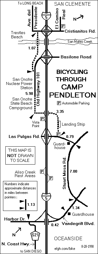
Bicycling Through Camp Pendleton
- Schematic map of the bike route through Camp Pendleton between
Oceanside and San Clemente. NOTE: For security reasons, this route
may be closed to civilian bicyclists.
-
Bicycling through South Escondido
- Schematic map and directions for bicyclists traveling between
Escondido and the Rancho Bernardo area of San Diego.
-
Bicycling through Mission Valley
- Schematic map and directions for bicyclists traveling in or through
Mission Valley in San Diego.
-
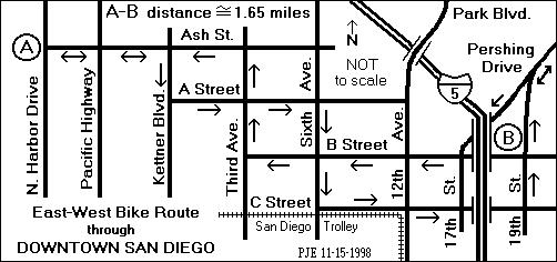
East-West Bike Route Through Downtown San Diego
- Schematic map of the bike route through Downtown San Diego between
N. Harbor Dr. and Pershing Dr.
| 


