 |
San Diego Bay Bike Route
San Diego, California
|
Please e-mail comments, corrections and additions to the webmaster at
pje@efgh.com.
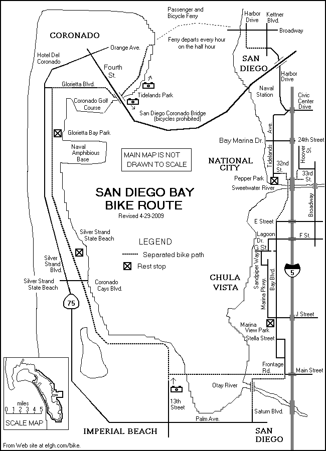
The San Diego Bay Bike Route is a delightful 24-mile, 2.5-hour ride with
no significant hills. Most of it runs along bike lanes or separated bike
paths. The scenery is rich and varied.
A ten-mile stretch along south and west sides of San Diego Bay follows
the former Coronado Branch of the San Diego and Arizona Eastern Railroad. The
rails are still visible in some places.
The official name of this route is the Bayshore Bikeway. This
name appears on newer signs in some places along the route. The name
"Bay Route Bikeway" appears on some older signs, although this name
has been disparaged because it is homophonic with "Beirut bikeway".
SANDAG (San Diego Association of Governments) has prepared a
Bayshore Bikeway Page. It contains
a history of the bikeway and two maps, and will soon contain an updated
fact sheet.
Directions:
- 0.00 - Start at the intersection of Broadway and Harbor Drive in Downtown San
Diego, right at the foot of Broadway Pier.
- Ride south along a bike path on the west side of Harbor Drive.
- 0.41 - Where Harbor Drive crosses Pacific Highway, the separated bike path
ends. Continue on Harbor Drive, past the San Diego Convention Center, under
the Coronado Bridge, past the 32nd Street Naval Station and past a sign
welcoming you to National City.
- 5.08- Just before the interchange with
Interstate 5, turn sharp right onto Civic Centre Drive.
- 5.24 - Civic Centre Drive turns left and becomes Tidelands
Avenue.
- 6.43 - Just before entering Pepper Park, turn left onto W. 32nd St.
(Pepper Park is a good place to stop for a rest.)
- 6.63 - Where W. 32nd St. turns left and becomes Marina Way, enter a
bike path and follow it across a railroad spur line at grade level.
- 6.98 - Soon after crossing the railroad spur, turn left through a break
in the retaining wall into the approach
to the Gordy Shields Bridge
over the Sweetwater River. This turn is poorly marked. Don't miss it! If
you pass under Interstate Highway 5, you've gone too far.
Cross the bridge and continue south on a bike path next to Interstate 5.
- 7.91 - At the end of the path, continue roughly straight ahead
on Bay Blvd. NOTE: To the right
is a road leading to the
Chula Vista Nature Center. Bicycles are not allowed on that
road. If you want to visit the Center, park your bike and take a short bus
ride.
- 8.19 - Turn right onto Lagoon Dr. (For a shorter but less scenic route,
you can continue straight ahead and rejoin the Bayshore Bikeway at 9.97.)
- 8.51 - The road turns left and becomes Marina Parkway.
- 8.79 - Turn right onto G Street.
- 8.86 - Turn left onto Sandpiper Way.
- 9.31 - Turn right onto a different segment of Marina Parkway.
- 9.97 - Turn right onto Bay Blvd. (On the southwest corner of Bay Boulevard
and Marina Parkway there is a
small park where you may want to stop for a brief rest. The
facilities include a rest room and drinking fountain.)
- ALTERNATE ROUTE: On March 24, 2012, a new bike path was opened.
Instead of
turning right into Bay Blvd., turn sharp right into the path. It
runs roughly parallel to Bay Blvd. and rejoins it at the junction
with Palomar St., about 1.2 miles to the south. The path bypasses
a small hill on Bay Blvd.
- 11.73 - Turn right onto Frontage Road.
- Somewhere along Frontage Road, you will re-enter the City of San Diego,
although there is no sign at the city limits.
- 12.00 - At the intersection of Main Street, enter a separated bike path
which goes due west. (Slightly farther south is the Saturn Bike Path,
which descends to an undeveloped area. It was part of the
Bayshore Bikeway until April 18, 2009.)
- 13.06 - Turn right where the path meets
another path. (The path to the left goes to the north end
of 13th St.)
Click here for a photograph of the path (25K).
- Follow the bike path along the south and west sides of San Diego Bay. Just
past the end of 7th Street, you will enter the City of Coronado, although
there is no sign at the city limits.
- 16.74 - Cross Coronado Cays Blvd. and continue north on a separated
bike path.
- You may want to stop again at Silver Strand State Park. There
is a fence between the bike path and the park, but at one point (about 0.8
mile north of Coronado Cays Blvd.) there is a short, paved path leading
through a gap in the fence and down to a rest room. You may also want to ride
around the park for a while. There are several tunnels under Silver Strand
Boulevard that will take you over to the ocean side of the park.
- Continue north on a separated bike path, passing the Naval Amphibious
Base.
- 20.77 - Just north of the Naval Amphibious Base is a small city park (Glorietta
Bay Park), with rest rooms and drinking water.
- 21.31 - Almost across the street from the famous Hotel del Coronado, the bike path
veers to the right to follow Pomona Avenue and Glorietta Boulevard eastward.
- 21.64 - The separated bike path ends near some tennis courts. Keep right and
follow Glorietta Boulevard, which runs along the north side of the Coronado
Golf Course.
- 22.65 - At the intersection with Fifth Street,
turn right onto a separated bike
path and follow it under the Coronado Bridge.
Click here for a photograph taken from the
path.(37K).
- On the other side of the bridge, the path splits. Keep right. (The left
branch is a drainage channel.) Enter Tidelands Park.
- Follow the paved bike path through Tidelands Park. Stay close to the bay.
As you emerge from Tidelands Park, you get your first really good view of
the Downtown San Diego skyline.
Click here for a photograph (30K).
- Continue past the Marriott Hotel (formerly the Le Meridien) all the way to
the Old Ferry Landing,
which is a small, tourist-oriented shopping center.
- 24.12 - The Bayshore Bikeway ends next to a pier.
Buy your one-way ferry ticket from a vending machine.
The fare is $7.00 (as of June 1, 2022). Credit cards are sometimes accepted.
You may also pay your fare in cash as you board the ferry.
- The ferry departs for Broadway Pier in Downtown San Diego every hour on
the half hour. A fifteen-minute ferry ride will take you back to the starting
point.
Return to home page
A Russian translation of this page is available at
paintingvalley.com/ru-san-diego
courtesy of
paintingvalley.com.
Click on cameras for pictures taken from the path.
Last revised April 29, 2009