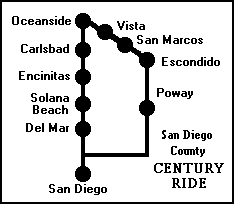
On September 30, 1998, I rode my first century ride (100 miles in a single day). It may well be my last, since I am past my prime and not getting any younger! (A few years later, I rode another century ride, which will probably be my last.)
NOTE:The San Luis Rey River Bike Path has been extended in 2003. The ride description has been modified to include the extension, for those who want to use it.
I had no SAG vehicle following me, but I wasn't entirely without support. If my bicycle had broken down, or if I had simply become too exhausted to continue, I could have caught a bus or the Coaster commuter train from many places along the way. I was familiar with the route, having ridden most of it in smaller pieces.
Much to my surprise, I was able to complete the ride, even though I am not a very strong rider. But I had a lot of things going for me. The weather was ideal (cool and partly cloudy, with little wind). The route has very few hills. I got an early start. Even so, took me 9 hours and 37 minutes, including about a half-hour for rest and lunch stops.
Here is a description of the route, with maps where they are available. A more detailed description of the coastal part of the route is available in the document Bicycling on Old U.S. 101 in San Diego County.
Since I do not live in Downtown San Diego, the route I followed differed slightly from this one at the southern end. But I did ride more than 100 miles (as shown by my bicycle odometer), and I have ridden the southern portions on other occasions.
00.00 Start in Downtown San Diego at the corner of Broadway and Pacific Highway. Go north on Pacific Highway.
01.80 Take the Frontage Rd. Washington St. exit. Do not ride on the bridge over Washington Street!
02.03 Turn left and then right at the traffic light to re-enter Pacific Highway. (If you enter the Frontage Road by mistake, there are several other places where you can re-enter Pacific Highway.)
03.56 Turn right onto Taylor St., which becomes Hotel Circle S.
05.86 Just after you pass under Interstate 8, turn right onto Camino de la Reina, which becomes Camino del Rio N. where it crosses Qualcomm Way (formerly called Stadium Way).
09.70 Turn left onto Ward Rd.
09.82 Turn left onto an unmarked road just past 24 Hour Fitness.
10.04 Pass under Interstate 15 and through a gate into the Qualcomm Stadium parking lot. Keep right and ride north along the west side of the parking lot.
10.37 Enter the Murphy Canyon bike path at the northeast corner of the stadium parking lot.
11.04 Emerge from the bike path and continue north on Murphy Canyon Rd.
13.80 Turn left onto Clairemont Mesa Blvd., using the pedestrian crossing signal if the left-turn traffic light does not respond.
13.91 Turn right onto Chesapeake Dr.
14.44 Turn right onto Ruffin Rd., which becomes Kearny Villa Rd.
18.64 Turn right onto Pomerado Rd.
18.91 Cross over Interstate 15, watching carefully for cars entering or leaving the freeway.
Pay no attention to the spurious signs that say "Entering San Diego County" and "Leaving San Diego County". You are in San Diego County and will remain in San Diego County during the entire ride.
22.76 Turn right at the top of the hill to stay on Pomerado Rd. To the left would be Spring Cyn Rd. Straight ahead would be Cypress Cyn Park Dr.
23.63 Enter Poway, the City in the Country.
26.90 Arbolitos Park to the right. A good place for a rest stop. Restrooms, drinking fountain, telephone are available.
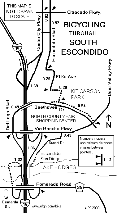
32.85 Turn left into the onramp to Interstate 15 NORTH. Yes, it is legal to ride on the freeway shoulder. Take the first exit, Via Rancho Parkway.
33.92 At the end of the Via Rancho Parkway offramp, use the pedestrian crosswalk to cross the offramp and turn around. Enter the Interstate 15 NORTH onramp. Take the first exit, Centre City Parkway.
38.55 Turn left onto Mission Ave., which becomes Mission Rd., S. Santa Fe Ave. and N. Santa Fe Ave. However, it is also known as San Diego County Highway S14 everywhere.
44.66 Pass Palomar College and the Palomar College Transit Center.
45.18 Be careful as you cross the railroad tracks near Pacific St. It's a fairly difficult crossing. There are no bike lanes. The next 0.22 miles also call for special care because the road is narrow.
47.51 Another railroad crossing.
48.07 Enter the City of Vista.
52.99 Enter the City of Oceanside.
53.83 Guajome Regional Park to the right. A good place for a rest stop. Restrooms and a drinking fountain are available.
54.43 Turn left onto Mission Ave., also known as California Highway 76. This is now an expressway with good bike lanes and lots of traffic.
54.95 Turn right onto College Blvd.
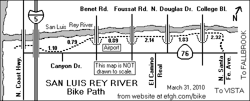
55.63 Enter a bike path just before crossing a bridge ofer the San Luis Rey River. Turn left, go under the bridge and enjoy a six-mile ride on the San Luis Rey River Bike Path, one of the best bike paths in San Diego County. (Extensions to this path have made the ride more than six miles long.)
60.64 After you pass under Benet Road, the pavement used to end. It has now been continued. If you want to follow the route that I followed on September 30, 1998, go back to Benet Road, take Benet Road south and turn right on Highway 76.
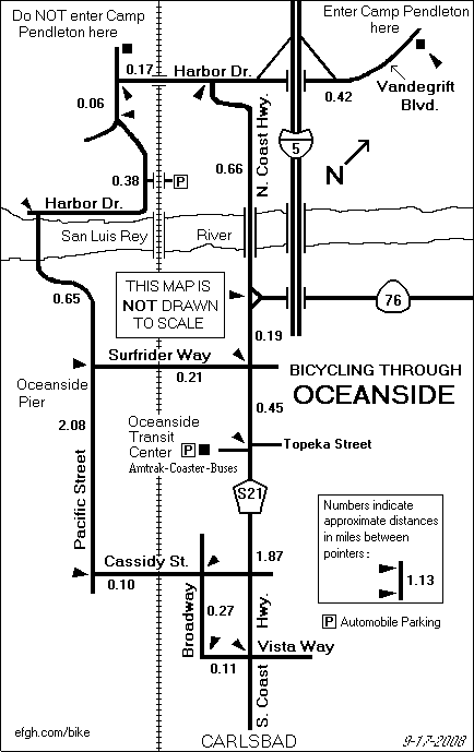
62.41 The bike path used to end here on Highway 76, just east of the interchange with Interstate 5. If you want to follow the old route, follow a short unpaved path to the highway and continue west on Highway 76. Otherwise, just continue on the path under Interestate 5.
The path swings south and emerges at the end of Neptune Way. Follow Neptune Way, turn right on Cleveland Street and turn right again on Coast Highway.
62.72 Turn left onto Coast Hwy., also known as San Diego County Highway S21. Follow Highway S21 down the coast about 24 miles. Rest rooms and drinking fountains are available at a number of state, county and local parks along the way. For a more detailed description of this part of the ride, see Bicycling on Old U.S. 101 in San Diego County
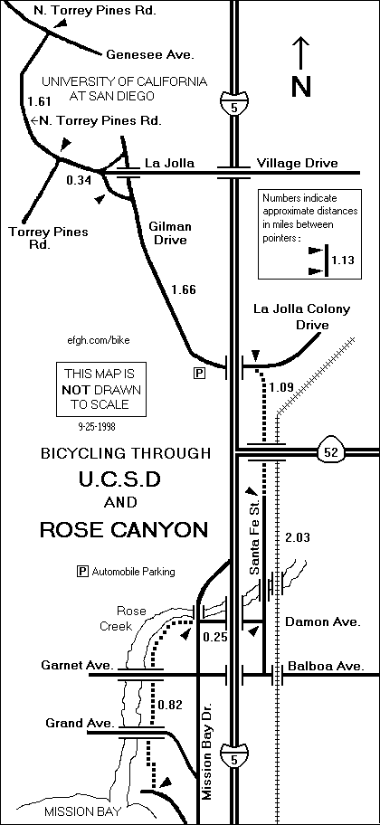
86.46 - Leave Highway S21 by turning right onto N. Torrey Pines Road. This intersection is a bit confusing, because the part of S21 that you have been riding on is also called N. Torrey Pines Road! (The road straight ahead is Genesee Ave.)
Follow N. Torrey Pines Road as it swings around the campus of the University of California at San Diego.
88.07 - Another confusing intersection. Torrey Pines Rd. goes to the right. Go straight ahead on La Jolla Village Dr.
88.41 Turn right onto Gilman Drive, and follow it down a long hill to an interchange with Interstate 5. (CAUTION: The sign for Gilman Drive is quite small; don't miss it!)
Ride very carefully past the entrance to southbound Interstate 5, especially when the traffic is heavy. Motorists entering Interstate 5 can make it difficult for a bicyclist to cross the entrance safely.
Pass under Interstate 5.
90.07 - On the other side, just beyond the exit from northbound Interstate 5, enter an unmarked bike path on your right.
Ride south along the bike path through Rose Canyon near the east side of Interstate 5, passing under Highway 52 and its interchange with Interstate 5.
91.16 - Emerge from the bike path and continue south on Santa Fe St.
93.19 - Turn right onto Damon Avenue and follow it under Interstate 5 to its end on Mission Bay Drive.
93.44 - Cross Mission Bay Drive and enter a bike path on the other side of the street.
Follow the bike path along the left bank of Rose Creek, passing under two bridges. Continue south until the bike path emerges on East Mission Bay Drive between a golf course and a boatyard.
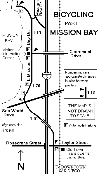
94.26 - Turn left and follow East Mission Bay Drive south. Restrooms and drinking water are available near several of the parking areas to your right, and at the Mission Bay Visitor Information Center.
97.08 - When East Mission Bay crosses Sea World Drive, it changes its name to Pacific Highway. Continue south on Pacific Highway and pass over Interstate 5.
98.09 - Cross Taylor Street (which goes east) and Rosecrans Street (which goes west). Continue south on Pacific Highway and pass under Interstate 5. You should recognize this area. At the beginning of the ride, you were going in the opposite direction on this road.
You could follow Pacific Highway all the way to Downtown San Diego. This is an official bike route, but there is a serious problem with the direct route.
The place where the southbound lanes of Pacific Highway merge with the eastbound lanes of Barnett Ave. is extremely dangerous for southbound bicyclists. There is no bike lane. Motorists approaching the area from the west cannot see very far ahead because the road curves and there is a retaining wall next to the inside of the curve. Therefore, I strongly recommend an alternate route.
98.72 - Just after passing under a pedestrian overcrossing, and just beyond the intersection of Enterprise Street, keep right. Do not follow the bike route sign, which would direct you down into a short tunnel. Follow an unmarked transition road to the right. It will lead you to the north side of Barnett Ave. Follow Barnett Ave. west to the first traffic light.
99.01 - At the traffic light, dismount and use the pedestrian crossing to cross over to the south side of Barnett Ave.
99.05 - Get back onto your bicycle and ride east on the south side of Barnett Ave.
99.16 - Just before the lanes descend, switch to the sidewalk. Ride or walk your bike on the sidewalk until you reach a point where it is safe to return to the street.
99.84 - As you approach the place where Pacific Highway rises to cross Washington Street, take the Washington Street exit. Do not ride on the bridge.
99.98 - Cross Washington Street and continue straight ahead. The entrance ramp will take you back to southbound Pacific Highway.
100.69 - Return to starting point at the corner of Broadway and Pacific Highway in Downtown San Diego.